Restoration Effectiveness Monitoring in the Vermilion River Active
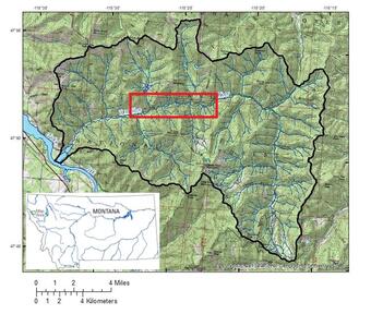
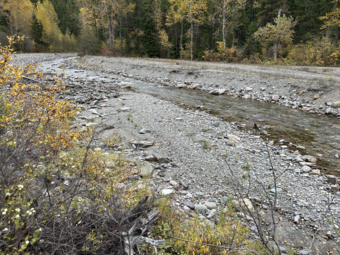
The Vermilion River is a major tributary to the Lower Clark Fork River in the northwest corner of Montana (Fig. 1) and is designated as critical habitat for migratory Bull Trout and Westslope Cutthroat Trout. Historic placer, hydraulic, and dredge mining and large-scale clearcutting (via commercial forestry) in the upper portion of the Vermilion River drainage have degraded the river habitat, increased the magnitude of flooding in the lower drainage, and caused persistent imbalance between erosion and sediment deposition (Fig. 2).


Three phases of the USFS Vermilion River Restoration Project, the Chapel Slide Reach (USFS Project 1, restored in 2012), the Miner’s Gulch Reach (USFS Project 2, restored in 2016), and the Sims Reach (USFS Project 3, restored in 2021), have already been completed (Fig. 3). The next several phases of restoration will target the Grouse, Rocker, and 100-ton reaches by 2026.


In cooperation with USFS, Sanders County, and other stakeholders, the USGS Wyoming-Montana Water Science Center is developing a restoration effectiveness monitoring program in multiple phases that will provide survey and hydrologic data and compare the physical, chemical, and biological characteristics of restored, unrestored, and reference (areas not impacted by mining) areas within the stream: surface water, groundwater, and riparian zones. Phase 1 (summer-fall 2023) includes (a) an uncrewed LiDAR and thermal imagery survey, (b) establishment of the monitoring network, (c) and instrumentation of shallow groundwater sites (Fig. 4). Phase 2 (summer 2024-spring 2025) will be the collection of physical, chemical, and biological data, including (a) groundwater levels and temperatures near the groundwater-surface water interface, (b) microbial community structure and function within the hyporheic zone and the groundwater-surface water interface, and (c) metabolism of the aquatic ecosystem based on carbon production and mineralization. Samples and data collected in Phase 2 will be from Grouse Reach (unrestored, USFS Project 4, designated “year 0” reach), Sims Reach (designated “year 3” reach, Fig. 5), Miner’s Gulch Reach (designated “year 8” reach), Chapel Slide Reach (designated “year 12” reach), and a reference site located in the nearby West Fisher/Silver Butte area (Figs. 1 and 3).
This web page will be updated as data and products become available.
Below are partners associated with this project.
The Vermilion River is a major tributary to the Lower Clark Fork River in the northwest corner of Montana (Fig. 1) and is designated as critical habitat for migratory Bull Trout and Westslope Cutthroat Trout. Historic placer, hydraulic, and dredge mining and large-scale clearcutting (via commercial forestry) in the upper portion of the Vermilion River drainage have degraded the river habitat, increased the magnitude of flooding in the lower drainage, and caused persistent imbalance between erosion and sediment deposition (Fig. 2).


Three phases of the USFS Vermilion River Restoration Project, the Chapel Slide Reach (USFS Project 1, restored in 2012), the Miner’s Gulch Reach (USFS Project 2, restored in 2016), and the Sims Reach (USFS Project 3, restored in 2021), have already been completed (Fig. 3). The next several phases of restoration will target the Grouse, Rocker, and 100-ton reaches by 2026.


In cooperation with USFS, Sanders County, and other stakeholders, the USGS Wyoming-Montana Water Science Center is developing a restoration effectiveness monitoring program in multiple phases that will provide survey and hydrologic data and compare the physical, chemical, and biological characteristics of restored, unrestored, and reference (areas not impacted by mining) areas within the stream: surface water, groundwater, and riparian zones. Phase 1 (summer-fall 2023) includes (a) an uncrewed LiDAR and thermal imagery survey, (b) establishment of the monitoring network, (c) and instrumentation of shallow groundwater sites (Fig. 4). Phase 2 (summer 2024-spring 2025) will be the collection of physical, chemical, and biological data, including (a) groundwater levels and temperatures near the groundwater-surface water interface, (b) microbial community structure and function within the hyporheic zone and the groundwater-surface water interface, and (c) metabolism of the aquatic ecosystem based on carbon production and mineralization. Samples and data collected in Phase 2 will be from Grouse Reach (unrestored, USFS Project 4, designated “year 0” reach), Sims Reach (designated “year 3” reach, Fig. 5), Miner’s Gulch Reach (designated “year 8” reach), Chapel Slide Reach (designated “year 12” reach), and a reference site located in the nearby West Fisher/Silver Butte area (Figs. 1 and 3).
This web page will be updated as data and products become available.
Below are partners associated with this project.

