
Topobathymetric Elevation Model of Outer Banks and Pamlico Sound, North Carolina
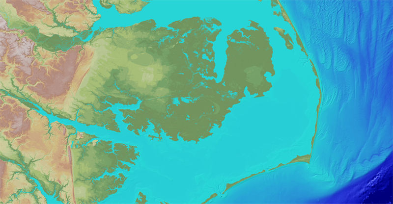
Pamlico Sound is ecologically important as it is the second largest estuary in the United States, and is the largest lagoon on the U.S. east coast. The sound is separated from the Atlantic Ocean by the Outer Banks, a series of low, sandy barrier islands that are vulnerable to hurricane storm surge and sea-level rise. The seamless high-resolution topobathymetric digital elevation model (TBDEM) for Outer Banks and Pamlico Sound, North Carolina, was developed in collaboration with the U.S. Geological Survey (USGS) Coastal and Marine Geology Program by merging topographic (land elevation) lidar data from USGS and bathymetric (water depth) data from National Oceanic and Atmospheric Administration, Naval Research Laboratory, Virginia Institute of Marine Science, and U.S. Army Corps of Engineers.
To view or download the Outer Banks and Pamlico Sound, North Carolina, topobathymetric elevation model, visit the CoNED Project Viewer or The National Map Viewer.
Below are other science projects associated with this project.

Coastal National Elevation Database (CoNED) Applications Project
Coastal National Elevation Database (CoNED) Applications Project
Pamlico Sound is ecologically important as it is the second largest estuary in the United States, and is the largest lagoon on the U.S. east coast. The sound is separated from the Atlantic Ocean by the Outer Banks, a series of low, sandy barrier islands that are vulnerable to hurricane storm surge and sea-level rise. The seamless high-resolution topobathymetric digital elevation model (TBDEM) for Outer Banks and Pamlico Sound, North Carolina, was developed in collaboration with the U.S. Geological Survey (USGS) Coastal and Marine Geology Program by merging topographic (land elevation) lidar data from USGS and bathymetric (water depth) data from National Oceanic and Atmospheric Administration, Naval Research Laboratory, Virginia Institute of Marine Science, and U.S. Army Corps of Engineers.
To view or download the Outer Banks and Pamlico Sound, North Carolina, topobathymetric elevation model, visit the CoNED Project Viewer or The National Map Viewer.
Below are other science projects associated with this project.
Coastal National Elevation Database (CoNED) Applications Project