
Cold Contacting Sources
Volunteers collecting data for The National Map Corps are not required to make phone calls, use email, or make in-person visits to contact authoritative resources. However, online methods may occasionally come up short for identifying location or address information for a structure. So, if it’s something you’re comfortable doing, cold contacting can be a great way to get the information you need.
A Simple Script
If cold contacting a source, here is a short script to represent yourself clearly and concisely within those first few seconds of a call or email.
‘Hello, my name is X____________ and I’m a volunteer for The National Map Corps with the U.S. Geological Survey. We are currently updating the [TYPE OF STRUCTURE,e.g., Schools] data for the US Topo maps, and I was hoping you could confirm the address of [NAME OF FEATURE].’
Which method to choose?
If you can find a phone number, this is often the fastest and most efficient way to reach a source. However, emailing can also be useful, and sometimes a combination of both work best to get the information you need. Also, when inquiring about a specific structure, it can be efficient to ask about other structures in the nearby area.
Examples
Example 1:
Structure: Saint Patrick's Cemetery
Action: Call and Email Follow-up
Result: A list of cemeteries for the Town of Hartland, NY
The Town of Hartland employs a Town Historian, whose responsibility is to collect and preserve the history of the people of the town. Seems like the right person to clarify cemetery data. A review of the town website yielded the name and number for the historian. He emailed me a list of active and inactive cemeteries after I followed-up on our call. Each cemetery included an address in the area of each cemetery to help locate each cemetery quickly on the map.
*NOTE: Since cemeteries rarely have complete physical addresses, it is acceptable to just include a single street name (e.g., ‘Smith Road’) or set of crossroads (e.g., ‘Smith Road and Cherry Lane’). Or, if the cemetery is located in a field nowhere near a road, then it is also acceptable to leave the Address 1 field blank. For additional guidance, check out the October 2021 newsletter article, ‘Overview of Cemetery Addresses‘.
‘Inactive’ cemeteries means that no new interments are happening, but those cemeteries should still be collected. Remember, the only time we delete a cemetery is if it physically doesn't exist anymore and the bodies have been disinterred. The only time a point for a cemetery that still has bodies should be deleted is if an area was flooded with a dam and the old cemetery is now underwater. Check out the September 2019 newsletter article, ‘Cemetery Research and Guidance’ for more information on the topic.

Example 2:
Structure: Connie Mack Cemetery
Action: Call
Result: A new point created
The City of Dyersburg website directory conveniently lists a cemetery link. It was the obvious choice to call to verify information for Fairview Cemetery in Dyersburg, Tennessee (center symbol) and also ask for information on nearby cemeteries. The source volunteered a new cemetery called ‘Connie Mack Cemetery’, located on the site of a former ball field, and appropriately named for a former baseball catcher and manager. Its location was confirmed by checking multiple aerial photo sources: NAIP, Google Maps, and Google Earth. The former ballfield was visible on the NAIP imagery, and the new cemetery can be seen on the Google imagery.


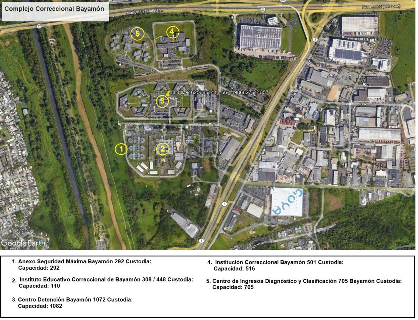
Example 3:
Structure: Complejo Correccional Baymon Prison Complex in Puerto Rico
Action: Email
Result: Added a point for the central prison building
Co-located structures, or structures occupying multiple buildings, e.g., schools and prison complexes, may be a bit more challenging to identify, so anything to increase your chances of getting a response is helpful. Here I annotated my screen grab with numbers. As a result, I was sent a table with matching number/building pairs for each building at the complex. Out of the 5 points annotated, I kept #3 (Center point) since that looks to be the central building with the highest inmate capacity.
Example 4:
Structure: St. Adalbert’s Cemetery
Action: Call and Email Follow-up
Result: Verified / created a point for New and Old Saint Adalbert’s Cemetery and Holy Mother of the Rosary Cemetery
This was a tricky structure to verify. The boundaries between the cemeteries, even with the obvious entrances and differing road designs, weren’t clear. Holy Mother of the Rosary Cemetery is nestled in between St. Adalbert’s Cemetery to the east and the Older St. Adalbert’s Cemetery the west. Here my source annotated the Google Maps screen grab., however, sending her my own most likely helped.

Tips
Have The Editor Open on Your Computer
Sometimes locational details are confusing, especially in rural areas or congested urban footprints. Use The National Map Base layer or The National Map + Aerial Imagery layer to make identification easier on-the-fly when referring to the point you are editing over the phone or via email.
Be Prepared to Educate
USGS? US Geological Survey? The National Map Corps? If your source has additional questions that you aren’t sure how to answer, tell them they may contact The National Map Corps team at nationalmapcorps@usgs.gov.
Public Information Disclosure
While information is already publicly available, sources may be hesitant to give it out or confirm. You can tell them you are calling to clarify information already posted publicly on the web. This is common with schools where addresses may be treated as private. It is best to be clear and transparent up front. If they choose not to assist you in identifying the structure, thank them for their time and move on to searching for another source.
Next time, you’re having a hard time verifying a structure online, take the plunge by communicating directly with a source. Again, we do not require volunteers to contact sources, however, it’s likely to yield more effective results.