
Geology of Denali National Park and Preserve
Plate tectonics play an important role in the geology of Denali National Park and Preserve.
Denali National Park and Preserve spans over 6 million acres in the heart of Alaska where spectacular mountains and glaciers encompass a remote sub-arctic wilderness. A majority of the land requires travel either by aircraft or on foot and there is only one road entering and exiting the park. Anchorage is the closest major city located 137 miles to the south. In 1917, the wilderness area became the first national park created specifically to protect wildlife, and then became a designated international biosphere reserve in 1976. Denali National Park and Preserve became its official name in 1980 to honor Denali Mountain, the highest point of North America.
Denali is well known for its elevation reaching 20,310 ft., but many people are unaware that Denali is actually a full mile taller than Mt. Everest. A mountains’ height is measured from base to summit. Denali measures around 18,000 ft from base to summit, while Mount Everest is around 5,000 ft less. This is possible because Mount Everest is the highest mountain on earth, but not the tallest. While Denali is technically taller, the base starts out at a lower elevation than Everest, reducing the overall height it can reach. Specifically, Denali’s base is located a mere 2,000 ft above sea level while Everest's base begins at 14,000 ft above sea level. So, while Everest reaches the highest point in the atmosphere, the distance from base to peak of Denali constitutes a greater vertical rise.
The name Denali derives from the Koyukon Alaska Native language, which translates to “Tall one”. Alaska has a rich Native American history and many other Athabascan tribes also had their own unique names for the mountain. The park and mountain experienced a recent name change from Mt. McKinley in 2015 under President Barack Obama. The mountain was dubbed McKinley at the start of the Alaskan gold rush to honor the (not yet elected) President McKinley. Despite the publicity he received from the naming of the mountain, President McKinley never once visited the state nor the mountain that bore his name. This, along with the close ties of the mountain to the Alaska Native community, was one of the principal arguments for returning it to the original name.

Denali’s elevation is a product of processes called plate tectonics. Tectonic plates on Earth’s surface essentially float on the underlying mantle. The mantle is partially molten and can move the plates on top of it due to convection currents within the mantle. In Alaska, these currents cause the tectonic plates referred to as the Pacific Plate and Yakutat microplate to move northward. As these plates have moved northward, they have collided with the stable North America Plate and, in this case, cause a mountain building period referred to as an orogeny.
The upward growth of a mountain is referred to as uplift. Mt. Denali is a part of the Alaska Range and the uplift of the range as a whole started during the Cenozoic era. The uplift of Denali National Park and Preserve is caused by the collision of tectonic plates as well as its location along a prominent fault. A geological fault is where significant amounts of rock have been displaced, and there is such a fault (aptly named the Denali fault) that has a bend where Denali is situated. This bend causes the rocks to stack on top of one another and increase the mountain's height. The fault itself runs almost 1,200 km long from the Yukon border all the way to the Bering sea. The Denali fault crosses most of Alaska’s width and is considered active, causing the height of Denali to increase by about .5 mm per year. There are many smaller faults throughout the park and preserve.

Denali mountain is composed primarily of igneous rocks crystallized from magma and metamorphic rocks. Metamorphic rocks are rocks that were changed or altered from their original state into something new, due to intense amounts of heat or pressure. Four particularly evident types of metamorphic rock in Denali are slate, marble, quartzite, and schist. The Pacific plate is an oceanic plate, and the North American plate on which Alaska sits is a continental plate. Oceanic plates are significantly denser than continental plates, so when they collide the lighter continental plate is lifted up as the oceanic plate slides under it.
Much of Alaska is composed of accreted terranes, a phrase which refers to fragments of other continents, ocean basins, and islands that collide and attach themselves to a new continent. The two major terranes are the Yukon-Tanana terrane which collided with Alaska around 225 million years ago, and the Talkeetna Superterrane which collided with Alaska 110 to 85 million years ago. There are other smaller terranes in Denali National Park and Preserve but these two make underlie the majority of the park's landforms. The collisions where accreted terranes are attached happens very slowly. In fact, the most recent collision of the Yakutat terrane with southern Alaska began around 30 million years ago and is still underway.
Much of Denali’s landscape was forged by glaciers and the resulting meltwater. Glacial melt refers to glacier water runoff that serves as a mechanism of erosion, wearing away rock and sediment over time. A very powerful form of erosion is the glacier itself, forming at the highest elevation where ice and snow won't melt due to the low temperatures. Eventually the glacier moves downhill under the force of gravity and its own immense weight. Movement of glaciers can carve valleys, ridges and other rock features and even form lakes if melted. These traveling glaciers can be so powerful that they may pick up large boulders and carry them downhill, depositing rocks in completely foreign terrain, often with completely different composition.
Denali mountain is known to be one of the coldest in the world. This is due to its high elevation and extreme northern location, which is much farther north than Mt. Everest. Denali National Park and Preserve contains over 400 glaciers, with the most well-known being the Kahiltna Glacier and the Ruth Glacier. Kahiltna Glacier is by far the longest glacier in the park at 44 miles long, while Ruth glacier is the thickest. The presence of the glaciers are supported by the high latitude of the park, elevation of the mountain, and the permanent snowpack above 7,000 ft elevation. The majority of Denali’s glaciation occurred during 4 widespread glaciation periods that encompassed much of North America in the past 3 million years.
Glaciers used to cover far more of Denali’s landscape but are slowly disappearing due to a warming planet. In fact, Alaska has warmed more than twice the rate of the rest of the United States.
Geology of Denali National Park and Preserve by Time Period
Precambrian: 4,600 million years - 541 million years ago
The oldest rocks in Denali National Park and Preserve originate from the late Precambrian and early Paleozoic era, and are found on the Yukon-Tanana terrane. These geologic units are metamorphic rocks such as schist, amphibolite, greenstone, and quartzite. These rocks were formed and then deformed by metamorphism in an ancient ocean basin when North America was still part of the supercontinent Rodinia.
Paleozoic: 541 million years - 251.9 million years ago
The Paleozoic was the start of volcanic activity in Denali and coincided with the breakup of the supercontinent. Layers containing mud, sand, marine life, and volcanic ash were deposited during this period and later deformed by extensive metamorphism. These limey mud layers were later metamorphosed into marble.
Ordovician: Common rocks in Denali National Park from the Ordovician period are chert, slate, greenstone, limestone, and dolostone.
Devonian: During the Devonian period, the area was an island arc (a chain of volcanic islands) which made limestone, lava flows, and volcanic ash dominant rock types.
Carboniferous-Permian: Due to the area being marine during this time period, the most common rocks are limestone, mudstone, and sandstone.
Mesozoic: 251.9 million years - 66 million years ago
The Mesozoic was a period of intense mountain building (orogeny), which led to many accreted terranes on the western edge of the continent. This led to deformation of the existing ocean basin. The Mesozoic encompasses the Triassic, Jurassic, and Cretaceous periods.
Triassic: Volcanic hotspot activity is evident from the remaining greenstone, tuffs, and basalt lava flows.
Jurassic-Cretaceous: The Jurassic and Cretaceous periods were dominated by formations of sandstone, argillite, conglomerates, limestones, and a large variety of other rock types. This represents widespread plate tectonic activity. The orogeny that led to the formation of the ancestral Alaska Range began in the Cretaceous period.
Cenozoic: 66 million years ago- present day
These time periods led to formations of large amounts of rhyolite, andesite, granite, and other intrusive igneous rocks at depth and sandstone and mudstone at the surface.
Tertiary: During the Tertiary period there was extensive faulting that created large basins that collected sediment. These basins led to the formation of many coal seams and swamp environments.
Quaternary: As recently as 6 million years ago, the rapid uplift of the Alaska Range was still underway. At the same time this uplift occurred, several ice age cycles occurred as well, contributing to glacial formations and diversion of major streams and rivers to flow north. Following these ice age cycles, the first vegetation and coniferous forests took root. Evidence of them can be found in many organic deposits in the park.
Notable Formations:
Wickersham Wall
One of the most well-known geological formations in Denali National Park and Preserve is the Wickersham Wall, which contains one of the highest continuous mountain faces in the world. Glaciers off of Wickersham wall can reach lengths of up to 45 miles long.
Kantishna Hills
The Kantishna Hills of Denali National Park and Preserve are composed of metamorphic rocks from the Precambrian to Paleozoic era, and contain geological features called dikes dating back to the Cretaceous period. Dikes are slabs or sheets of rock that form in fractures of pre-existing rock beds. One of the most interesting geological features of the Kantishna Hills is the Kantishna Hills Anticline, which is underlain by a cluster of recent earthquakes and is actively deflecting river courses. An anticline is where rock beds have been folded into an arch by tectonic activity, with the oldest rock beds at the center of the arch.
Polychrome Overlook
Polychrome overlook is a popular stop on the one road winding through Denali, notable for its multi-colored rock and sediment caused by the volcanism. Volcanism was active in the park as recently as 38 million years ago, though these rocks formed closer to 56 million years ago. The rocks are composed of rhyolite tuffs, layered with other volcanic flows.
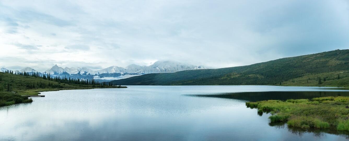
Wonder Lake
Wonder lake is a kettle lake and reaches a depth of 268 feet. A kettle lake is a lake the forms in depressions left by receding ice blocks that fill with water. There are many opportunities for viewing waterfowl as this region of Denali tends to be wetter than other areas in the park. It is also a popular camping and hiking destination.

Eielson Visitor Center
Eielson Visitor Center is open only during summer but is well known for being near some of the best Denali views. From the visitor center you can see evidence of some of the parks most recent volcanism which formed Mt Galen. Mt Galen is primarily composed of basalt, dacite, rhyolite, and andesite lava formations.
Teklanika Campground
Visiting Teklanika Campground, you would be standing atop what is called the Cantwell Formation. The Cantwell Formation is significantly younger than the rocks below it, meaning that there is a gap in the time record referred to by geologists as an unconformity. The gap in time amounts to somewhere between 65-100 million years of “missing time”.