
Crest-Stage Gages in Vermont Record High Peaks in Flash Flood Events
Record high water levels were measured at two crest-stage gages in Vermont this summer, during two different flood events, according to preliminary data.
During flash flooding in Vermont at the end of July, a crest-stage gage was over-topped by water. While most of the USGS continuous streamflow monitoring stations in the greater St. Johnsbury area of Vermont did not record the highest flood for the year during the July 30 flood, preliminary data from a crest-stage gage on Joes Brook Tributary in East Barnet recorded the highest peak in the stations 35-year history. The water level crested at 18.66 ft on July 30, surpassing the historical peak of 18.63 ft recorded on May 27, 2011. In the beginning of the month, a flood-event in Montpelier caused the crest-stage gage on Sunny Brook to reach 10.98 feet – the highest peak in the station’s 36-year period of record.
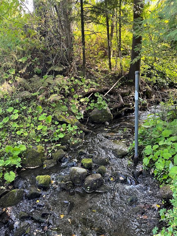
Crest-stage-gages are low-tech devices that provide a one-time measurement of the maximum height, or peak stage, a stream reaches during a flood. By monitoring smaller streams, crest-stage gages provide a more comprehensive picture as to how far and how high flood waters reach.
In Vermont, USGS has a network of 27 crest-stage gages on small streams with drainage areas less than 10 square miles. This is the only crest-stage gage network in all of New England.
“The network is a low-cost means to obtain a more representative sample for determining flood magnitude and frequency and allows us to not only better understand widespread flooding, but also flash flooding like that experienced in the St. Johnsbury area on July 30, 2024,” said USGS Supervisory Hydrologic Technician Richard Kiah.
Crest-stage gages are made of a metal pipe, a wooden pole, and crushed cork that are placed on the edges of rivers. Holes drilled into the bottom of the metal pipe allow water to enter and rise. Inside of the pipe is a wooden rod and ground cork. As the water in the stream rises during a flood, so too does the water within the pipe with the ground cork floating on the surface. Once the water stops rising and falling, the ground cork sticks to the rod at the highest point the water reached.
The crest-stage gage network was established in 1963 to evaluate the methods used to estimate flood severity and frequency, which only used large streams at the time. Most USGS crest-stage gages are used to verify the peak streamflows recorded at a streamgage.
“Including a network that focused on small streams was done to improve the understanding of all of Vermont streams by collecting a more representative sample,” Kiah said.
USGS, in cooperation with the Vermont Highway Department and Federal Highway Administration, operated the original crest-stage gage network until 1974; it was re-established in 1999 in cooperation with the Vermont Agency of Transportation and the USGS Groundwater and Streamflow Information Program.