
This animated GIF is a map of the United States and its territories shows geographic extent of planned, existing, and in-progress 3DEP data acquisition projects by year.
What geographic areas do 3D Elevation Program (3DEP) contours cover?
3D Elevation Program (3DEP) contours cover all of the United States and its territories at multiple scales:
- Small scales (1:578,000-1:289,000)
- Medium scales (1:144,000-1:72,000)
- Large scales (1:36,000-1:18,000)
Contours are easily viewed in The National Map Viewer and USGS topographic maps, or downloaded through The National Map Download Client.
Learn more: Map Scales
Related

Are 3D Elevation Program (3DEP) contour lines updated and what sources were used to create them? Are 3D Elevation Program (3DEP) contour lines updated and what sources were used to create them?
When significant changes in the landscape have occurred, contours will be updated on an as-needed basis. The 100-foot contours were derived from 3DEP (formerly National Elevation Dataset) one arc-second resolution data that was sub-sampled to a cell size of three arc-second. The 50-foot contours were also derived from one arc-second data. Large-scale contours were derived from 1/3 arc-second...

Are depression contours identified in 3D Elevation Program (3DEP) contour products? Are depression contours identified in 3D Elevation Program (3DEP) contour products?
Yes, depression contours are identified with tick marks in 3D Elevation Program products, but only in large scale contours (1:36,000 scale to 1:18,000 scale).

At what scales are contours visible in The National Map Viewer? At what scales are contours visible in The National Map Viewer?
In the default base map for The National Map Advanced Viewer: 500-foot contours are visible at a scale of 1:578,000 (zoom level 10) 100-foot contours are visible at scales of 1:289,000-1:144,000 (zoom level 11-12) 50-foot contours are visible at a scale of 1:72,000 (zoom level 13) Large scale contours are visible at scales from 1:36,000-1:9,000 (zoom levels 14-16)
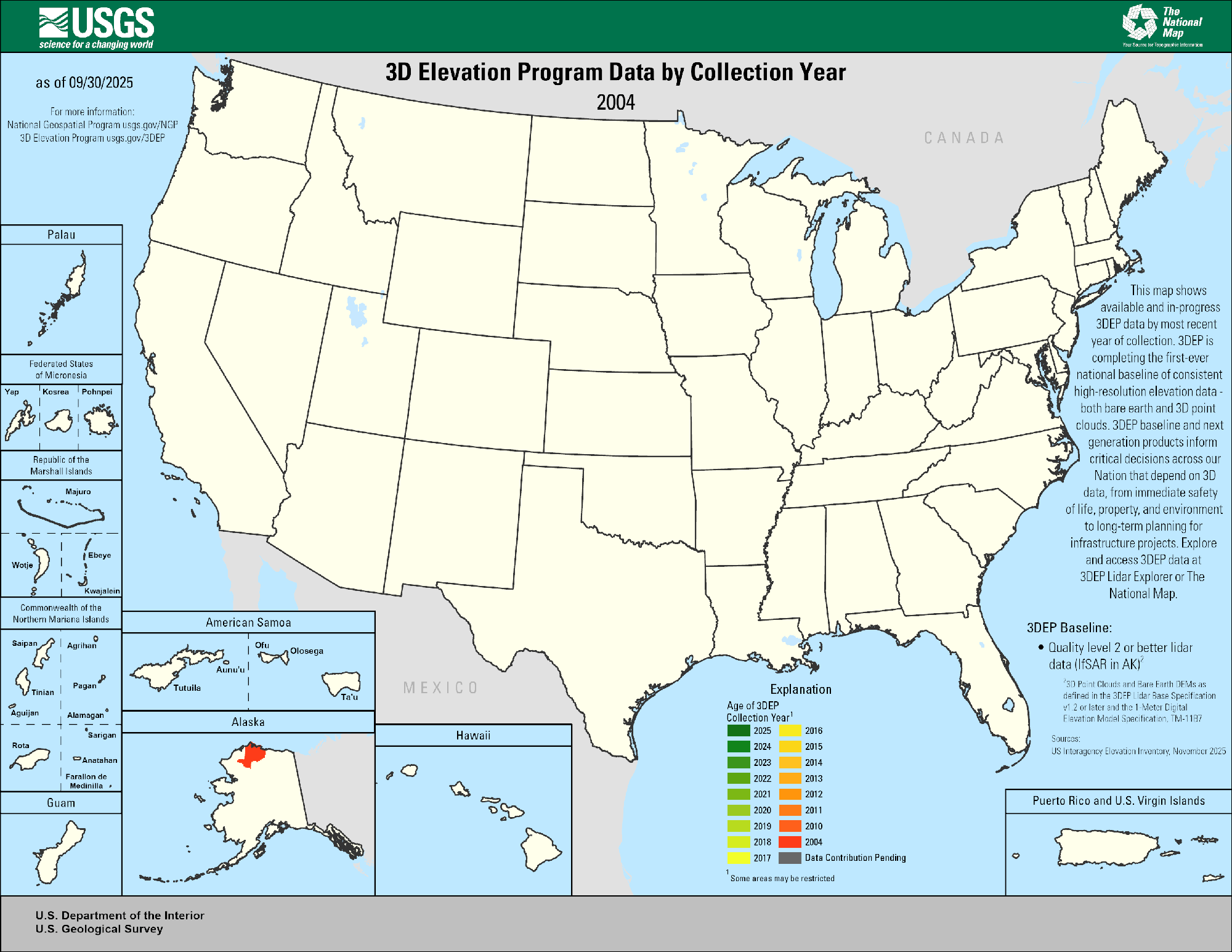
3DEP Quality Data by Collection Year Animated GIF
This animated GIF is a map of the United States and its territories shows geographic extent of planned, existing, and in-progress 3DEP data acquisition projects by year.

Post Wildfire Lidar-derived DSM of the Area Around Topanga Beach, Los Angeles, CA
Post Wildfire Lidar-derived DSM of the Area Around Topanga Beach, Los Angeles, CAPost Wildfire Lidar-derived DSM of the Area Around Topanga Beach, Los Angeles, CA with a green to brown symbology
Post Wildfire Lidar-derived DSM of the Area Around Topanga Beach, Los Angeles, CA
Post Wildfire Lidar-derived DSM of the Area Around Topanga Beach, Los Angeles, CAPost Wildfire Lidar-derived DSM of the Area Around Topanga Beach, Los Angeles, CA with a green to brown symbology

Theodore Roosevelt National Park 3DEP Lidar derived DEM 3D Blue Green
Theodore Roosevelt National Park 3DEP Lidar derived DEM 3D Blue Green3D view of Theodore Roosevelt National Park from 3DEP Lidar derived DEM USGS_OPR_McKenzie_County_2014_QL2_Lidar
Theodore Roosevelt National Park 3DEP Lidar derived DEM 3D Blue Green
Theodore Roosevelt National Park 3DEP Lidar derived DEM 3D Blue Green3D view of Theodore Roosevelt National Park from 3DEP Lidar derived DEM USGS_OPR_McKenzie_County_2014_QL2_Lidar

3D model of Pu‘u ‘Ō‘ō's crater
This 3D model of Pu‘u ‘Ō‘ō's crater was created from thermal images during an overflight of the cone. The deepest portion of the crater is about 320 meters (1050 feet) below the crater floor that existed prior to April 30.
This 3D model of Pu‘u ‘Ō‘ō's crater was created from thermal images during an overflight of the cone. The deepest portion of the crater is about 320 meters (1050 feet) below the crater floor that existed prior to April 30.

A 3DEP Image of Alaska's Denali Mountain
An oblique perspective of Alaska's Denali Mountain visualized by 3D Elevation Program lidar data.
An oblique perspective of Alaska's Denali Mountain visualized by 3D Elevation Program lidar data.

3DEP lidar Washington Monument, D.C. oblique view
A 3D dimensional oblique visualization made by 3DEP lidar point cloud of the Washington Memorial, Washington D.C.
A 3D dimensional oblique visualization made by 3DEP lidar point cloud of the Washington Memorial, Washington D.C.

3DEP, El Paso
3D elevation data for El Paso, Texas, in the form of a lidar point cloud. These data along with other products provide valuable productivity, safety, and cost-saving benefits to instrastructure improvement projects. I(mage provided by Jason Stoker - USGS).
3D elevation data for El Paso, Texas, in the form of a lidar point cloud. These data along with other products provide valuable productivity, safety, and cost-saving benefits to instrastructure improvement projects. I(mage provided by Jason Stoker - USGS).

PubTalk 11/2004 — From Plane Tables to Pixels
The Revolution in Mapping at the U.S. Geological Survey
by Susan P. Benjamin, Research Geographer
The Revolution in Mapping at the U.S. Geological Survey
by Susan P. Benjamin, Research Geographer
Related
Are 3D Elevation Program (3DEP) contour lines updated and what sources were used to create them? Are 3D Elevation Program (3DEP) contour lines updated and what sources were used to create them?
When significant changes in the landscape have occurred, contours will be updated on an as-needed basis. The 100-foot contours were derived from 3DEP (formerly National Elevation Dataset) one arc-second resolution data that was sub-sampled to a cell size of three arc-second. The 50-foot contours were also derived from one arc-second data. Large-scale contours were derived from 1/3 arc-second...
Are depression contours identified in 3D Elevation Program (3DEP) contour products? Are depression contours identified in 3D Elevation Program (3DEP) contour products?
Yes, depression contours are identified with tick marks in 3D Elevation Program products, but only in large scale contours (1:36,000 scale to 1:18,000 scale).
At what scales are contours visible in The National Map Viewer? At what scales are contours visible in The National Map Viewer?
In the default base map for The National Map Advanced Viewer: 500-foot contours are visible at a scale of 1:578,000 (zoom level 10) 100-foot contours are visible at scales of 1:289,000-1:144,000 (zoom level 11-12) 50-foot contours are visible at a scale of 1:72,000 (zoom level 13) Large scale contours are visible at scales from 1:36,000-1:9,000 (zoom levels 14-16)
3DEP Quality Data by Collection Year Animated GIF
This animated GIF is a map of the United States and its territories shows geographic extent of planned, existing, and in-progress 3DEP data acquisition projects by year.
This animated GIF is a map of the United States and its territories shows geographic extent of planned, existing, and in-progress 3DEP data acquisition projects by year.
Post Wildfire Lidar-derived DSM of the Area Around Topanga Beach, Los Angeles, CA
Post Wildfire Lidar-derived DSM of the Area Around Topanga Beach, Los Angeles, CAPost Wildfire Lidar-derived DSM of the Area Around Topanga Beach, Los Angeles, CA with a green to brown symbology
Post Wildfire Lidar-derived DSM of the Area Around Topanga Beach, Los Angeles, CA
Post Wildfire Lidar-derived DSM of the Area Around Topanga Beach, Los Angeles, CAPost Wildfire Lidar-derived DSM of the Area Around Topanga Beach, Los Angeles, CA with a green to brown symbology
Theodore Roosevelt National Park 3DEP Lidar derived DEM 3D Blue Green
Theodore Roosevelt National Park 3DEP Lidar derived DEM 3D Blue Green3D view of Theodore Roosevelt National Park from 3DEP Lidar derived DEM USGS_OPR_McKenzie_County_2014_QL2_Lidar
Theodore Roosevelt National Park 3DEP Lidar derived DEM 3D Blue Green
Theodore Roosevelt National Park 3DEP Lidar derived DEM 3D Blue Green3D view of Theodore Roosevelt National Park from 3DEP Lidar derived DEM USGS_OPR_McKenzie_County_2014_QL2_Lidar
3D model of Pu‘u ‘Ō‘ō's crater
This 3D model of Pu‘u ‘Ō‘ō's crater was created from thermal images during an overflight of the cone. The deepest portion of the crater is about 320 meters (1050 feet) below the crater floor that existed prior to April 30.
This 3D model of Pu‘u ‘Ō‘ō's crater was created from thermal images during an overflight of the cone. The deepest portion of the crater is about 320 meters (1050 feet) below the crater floor that existed prior to April 30.
A 3DEP Image of Alaska's Denali Mountain
An oblique perspective of Alaska's Denali Mountain visualized by 3D Elevation Program lidar data.
An oblique perspective of Alaska's Denali Mountain visualized by 3D Elevation Program lidar data.
3DEP lidar Washington Monument, D.C. oblique view
A 3D dimensional oblique visualization made by 3DEP lidar point cloud of the Washington Memorial, Washington D.C.
A 3D dimensional oblique visualization made by 3DEP lidar point cloud of the Washington Memorial, Washington D.C.
3DEP, El Paso
3D elevation data for El Paso, Texas, in the form of a lidar point cloud. These data along with other products provide valuable productivity, safety, and cost-saving benefits to instrastructure improvement projects. I(mage provided by Jason Stoker - USGS).
3D elevation data for El Paso, Texas, in the form of a lidar point cloud. These data along with other products provide valuable productivity, safety, and cost-saving benefits to instrastructure improvement projects. I(mage provided by Jason Stoker - USGS).
PubTalk 11/2004 — From Plane Tables to Pixels
The Revolution in Mapping at the U.S. Geological Survey
by Susan P. Benjamin, Research Geographer
The Revolution in Mapping at the U.S. Geological Survey
by Susan P. Benjamin, Research Geographer
Updated Date: June 23, 2026