
Chehalis Watershed Suspended Sediment Monitoring.PNG

Detailed Description
Sediment Sample Bottles
Sources/Usage
Public Domain.
Related
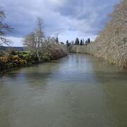
Chehalis Watershed Suspended Sediment Monitoring
The USGS monitored sediment loads in the Chehalis River and its major tributaries, allowing comparisons with historical monitoring. As a result, we now have a better understanding of modern sediment loads and how those loads have changed since the 1960s in response to improved land use practices. This information helps the U.S. Army Corps of Engineers maintain shipping access in Grays Harbor.
Related
Chehalis Watershed Suspended Sediment Monitoring
The USGS monitored sediment loads in the Chehalis River and its major tributaries, allowing comparisons with historical monitoring. As a result, we now have a better understanding of modern sediment loads and how those loads have changed since the 1960s in response to improved land use practices. This information helps the U.S. Army Corps of Engineers maintain shipping access in Grays Harbor.