
Thermal infrared imaging of groundwater discharge
Detailed Description
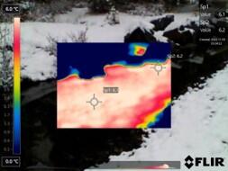
Because of thermal contrasts between inflowing groundwater and streams, USGS scientists use thermal infrared cameras to identify zones of groundwater discharge, as seen in this photograph.
Sources/Usage
Public Domain.
Related
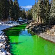
Quantifying groundwater recharge and discharge dynamics in the Upper Colorado River Basin
The Upper Colorado River Basin (UCOL) serves as an important source of water to millions of people, supports irrigation for agriculture, and provides aquatic habitat for a variety of species. Salinity concentrations endanger water supply in the Colorado River Basin, potentially causing hundreds of millions of dollars in annual economic damage because of corrosion of infrastructure, water treatment...
Related
Quantifying groundwater recharge and discharge dynamics in the Upper Colorado River Basin
The Upper Colorado River Basin (UCOL) serves as an important source of water to millions of people, supports irrigation for agriculture, and provides aquatic habitat for a variety of species. Salinity concentrations endanger water supply in the Colorado River Basin, potentially causing hundreds of millions of dollars in annual economic damage because of corrosion of infrastructure, water treatment...