
No matter the season, we are out monitoring Colorado waters.
In winter...
In winter...
No matter the season, we are out monitoring Colorado waters.
In spring...
In spring...
No matter the season, we are out monitoring Colorado waters.
In summer...
In summer...
No matter the season, we are out monitoring Colorado waters.
and in the fall.
and in the fall.
Colorado Water Science Center
Welcome to the USGS Colorado Water Science Center! Please use these pages to explore the hydrologic data and scientific investigations we conduct on Colorado water resources.
NOTICE: USGS is improving the way that sample data are stored and served to the public.
Current Conditions
Current Conditions
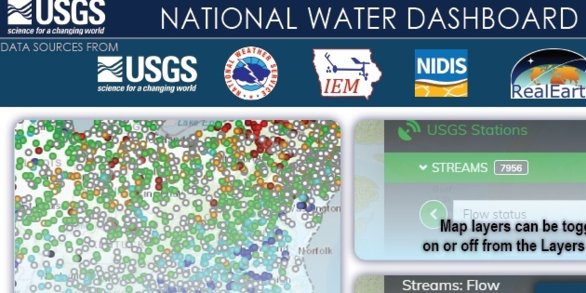
Explore real-time Colorado streamflow, groundwater, and water-quality conditions.
Science Highlight
Science Highlight

Next Generation Water Observing System: Upper Colorado River Basin
The Next Generation Water Observing System provides high-fidelity, real-time data on water quantity, quality, and use to support modern water prediction and decision-support systems that are necessary for informing water operations on a daily basis and decision-making during water emergencies.
News
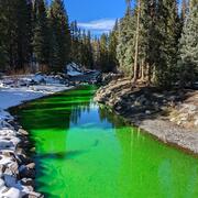
Media Alert: USGS Hydrologic Study to Use Non-Toxic Dye in Lake Fork Creek
Media Alert: USGS Hydrologic Study to Use Non-Toxic Dye in Lake Fork Creek
2025 USGS 'STREAM' Workshop: Science, Technology, Research, and Evaluations for Actionable Management
2025 USGS 'STREAM' Workshop: Science, Technology, Research, and Evaluations for Actionable Management
Media Alert: USGS Dye Tracing Study in Fraser River
Media Alert: USGS Dye Tracing Study in Fraser River
Publications
Effect of rotenone treatment on alpine stream invertebratecommunities in Colorado Effect of rotenone treatment on alpine stream invertebratecommunities in Colorado
Objective: Introduction of non-native salmonids to western United States streams has resulted in extirpation and even extinction of native cutthroat trout. Once thought to be extinct, a genetically verified population of Greenback Cutthroat Trout (GBCT) Oncorhynchus virginalis stomias was identified and used for population re-establishment efforts. To restore native trout habitat, stream...
Determination of baseline water-quality conditions using continuous specific conductance and discrete measurements of total dissolved solids and selected major ions, Arkansas River Basin, Colorado Determination of baseline water-quality conditions using continuous specific conductance and discrete measurements of total dissolved solids and selected major ions, Arkansas River Basin, Colorado
From 2022 through 2024, the U.S. Geological Survey (USGS) in cooperation with the Regional Resources Planning Group (Southeastern Colorado Water Conservancy District, Colorado Springs Utilities, Pueblo Water, Lower Arkansas Valley Water Conservancy District, Aurora Water, and Upper Arkansas Water Conservancy District) established a basinwide water-quality monitoring network in the...
Mercury biomagnification across food webs with varying non-native fish presence: Implications for native fish conservation in the upper Colorado River Basin Mercury biomagnification across food webs with varying non-native fish presence: Implications for native fish conservation in the upper Colorado River Basin
Environmental contaminants and non-native species introductions negatively affect aquatic ecosystem conservation. Mercury (Hg) accumulates within food webs where it can biomagnify to toxic concentrations, which can be affected by altered trophic relationships from non-native species. This study examined Hg concentrations (n samples = 655) and stable carbon and nitrogen isotope (n = 746)
Science
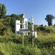
Next Generation Water Observing System (NGWOS) - Advancing Soil Moisture Monitoring
Soil moisture is an important part of the climate system, but it remains difficult to measure accurately. In 2022, the U.S. Geological Survey (USGS) began building a soil moisture monitoring network to provide high-quality continuous soil moisture data, standardize data collection methods, and test new technologies. Stations are placed in different climates and land cover types to capture a broad...
Quantifying groundwater recharge and discharge dynamics in the Upper Colorado River Basin
The Upper Colorado River Basin (UCOL) serves as an important source of water to millions of people, supports irrigation for agriculture, and provides aquatic habitat for a variety of species. Salinity concentrations endanger water supply in the Colorado River Basin, potentially causing hundreds of millions of dollars in annual economic damage because of corrosion of infrastructure, water treatment...
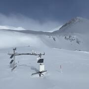
Next Generation Water Observing System (NGWOS) Snow Hydrology Monitoring Network in the Upper Colorado River Basin
Representative observations of snowpack conditions are vital for informing water availability assessments and modeling in snow dominated regions of the western United States. The U.S. Geological Survey (USGS) established a snow hydrology monitoring network in 2021 with the objective of providing high-quality, representative, and publicly available data on snowpack, soil moisture, and...