
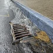
Three-dimensional view of stormwater catch basin locations and stormwater pipes near the Mystic River in Medford, Massachusetts

Detailed Description
Three-dimensional view of imagery, stormwater catch basin locations, and stormwater pipes near the Mystic River in Medford, Massachusetts
Sources/Usage
Public Domain.
Related
Integrating Stormwater Drainage into USGS StreamStats Application for the Duwamish and Lower Green River
The U.S. Geological Survey (USGS) is developing a Duwamish and Lower Green River Storm Drain StreamStats application to help communities and decision-makers address stormwater challenges in the Duwamish and Lower Green River watershed. This free, publicly accessible tool will allow users to delineate stormwater drainage areas and calculate basin characteristics, supporting climate resiliency and...
USGS New England Water Science Center Priorities and Programs
A look at what USGS water science centers do and the New England Water Science Center's current areas of focus and research.

Delineating High-Resolution Urban Drainage Systems for Stormwater Management in the Mystic River Watershed
Characterizing hydrology and pollutant inputs in urban watersheds requires the consideration of both the natural and manmade environment. The Mystic River Basin is a highly urbanized, 76-square-mile watershed north of Boston, Massachusetts, that includes several underserved communities. The U.S. Geological Survey (USGS) developed a watershed-scale web application of the Mystic River Basin to...
Related
Integrating Stormwater Drainage into USGS StreamStats Application for the Duwamish and Lower Green River
The U.S. Geological Survey (USGS) is developing a Duwamish and Lower Green River Storm Drain StreamStats application to help communities and decision-makers address stormwater challenges in the Duwamish and Lower Green River watershed. This free, publicly accessible tool will allow users to delineate stormwater drainage areas and calculate basin characteristics, supporting climate resiliency and...
USGS New England Water Science Center Priorities and Programs
A look at what USGS water science centers do and the New England Water Science Center's current areas of focus and research.
Delineating High-Resolution Urban Drainage Systems for Stormwater Management in the Mystic River Watershed
Characterizing hydrology and pollutant inputs in urban watersheds requires the consideration of both the natural and manmade environment. The Mystic River Basin is a highly urbanized, 76-square-mile watershed north of Boston, Massachusetts, that includes several underserved communities. The U.S. Geological Survey (USGS) developed a watershed-scale web application of the Mystic River Basin to...