
Elizabeth Jachens
Elizabeth Jachens is a hydrologist with the U.S. Geological Survey in the California Water Science Center in the Groundwater Availability and Use Assessments project.
Elizabeth graduated with her Ph.D. in Water Resources Engineering from Oregon State University in March of 2020. Her research focused on the use of recession analysis to characterize watershed responses to drought. She earned an M.S. in Water Resources Engineering and a Graduate Certificate in Water Conflict Management and Transformation, both from Oregon State University in 2019. Elizabeth graduated with a B.S. in Civil Engineering with a minor in math from California State University, Chico in 2015.
Science and Products
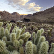
Drought versus Aridification in the Colorado River Basin
The Colorado River Basin is no stranger to drought. However, not all droughts are the same. Drought refers to a temporary state where conditions eventually return to normal. Aridification is the transition to persistent above-average dry conditions that do not return to normal. It is important to know whether the current, prolonged millennium drought (2000-present) is actually the first stages of...

Water Availability of the Salton Sea Watershed
Throughout history, the Salton Sea has formed and dried up due to flooding from the Colorado River. It was most recently formed in 1905 when the Colorado River broke through an irrigation canal and flowed uncontrolled into the Salton Sea watershed. The Salton Sea is a terminal lake (it has no outlets). It is also a transboundary watershed, with area in both the state of California and Mexico’s...
Science and Products
Drought versus Aridification in the Colorado River Basin
The Colorado River Basin is no stranger to drought. However, not all droughts are the same. Drought refers to a temporary state where conditions eventually return to normal. Aridification is the transition to persistent above-average dry conditions that do not return to normal. It is important to know whether the current, prolonged millennium drought (2000-present) is actually the first stages of...
Water Availability of the Salton Sea Watershed
Throughout history, the Salton Sea has formed and dried up due to flooding from the Colorado River. It was most recently formed in 1905 when the Colorado River broke through an irrigation canal and flowed uncontrolled into the Salton Sea watershed. The Salton Sea is a terminal lake (it has no outlets). It is also a transboundary watershed, with area in both the state of California and Mexico’s...