A view looking across the Connecticut River from a USGS streamgage in Suffield, Connecticut.

Official websites use .gov
A .gov website belongs to an official government organization in the United States.
Secure .gov websites use HTTPS
A lock () or https:// means you’ve safely connected to the .gov website. Share sensitive information only on official, secure websites.
Nigel Pepin is a Hydrologic Technician in the New England Water Science Center.
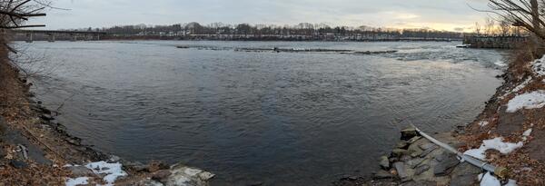
A view looking across the Connecticut River from a USGS streamgage in Suffield, Connecticut.
A view looking across the Connecticut River from a USGS streamgage in Suffield, Connecticut.
A view looking across the Connecticut River from a USGS streamgage in Suffield, Connecticut.
A view looking across the Connecticut River from a USGS streamgage in Suffield, Connecticut.

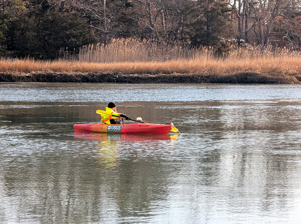
USGS hydrologic technician Virginia Stanley is towing an acoustic doppler current profiler (ADCP) behind a kayak on the Quinebaug River in Putnam, Connecticut, to capture streamflow measurements.
USGS hydrologic technician Virginia Stanley is towing an acoustic doppler current profiler (ADCP) behind a kayak on the Quinebaug River in Putnam, Connecticut, to capture streamflow measurements.
USGS hydrologic technician Ryan Botoroff anchored a kayak to position the attached acoustic doppler current profiler (ADCP) over a water quality sensor on the bottom of the Farm River installed to measure water velocity.
USGS hydrologic technician Ryan Botoroff anchored a kayak to position the attached acoustic doppler current profiler (ADCP) over a water quality sensor on the bottom of the Farm River installed to measure water velocity.

A USGS hydrologist takes a low streamflow measurement using a Parshall flume at the Pendleton Hill Brook near Clark Falls, Connecticut (station 01118300).
A USGS hydrologist takes a low streamflow measurement using a Parshall flume at the Pendleton Hill Brook near Clark Falls, Connecticut (station 01118300).

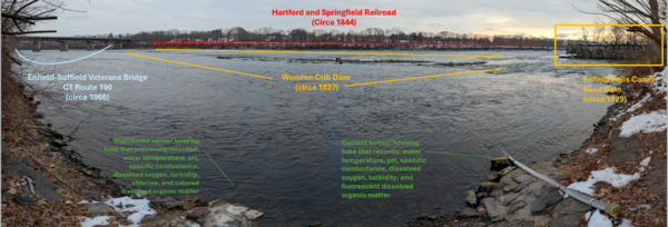
Station 01184100 Stony Brook near West Suffield, Connecticut.
Station 01184100 Stony Brook near West Suffield, Connecticut.

Station 01184100 Stony Brook near West Suffield, Connecticut.
Station 01184100 Stony Brook near West Suffield, Connecticut.
A view looking across the Connecticut River from a USGS streamgage in Suffield, Connecticut.
A view looking across the Connecticut River from a USGS streamgage in Suffield, Connecticut.
A view looking across the Connecticut River from a USGS streamgage in Suffield, Connecticut.
A view looking across the Connecticut River from a USGS streamgage in Suffield, Connecticut.
USGS hydrologic technician Virginia Stanley is towing an acoustic doppler current profiler (ADCP) behind a kayak on the Quinebaug River in Putnam, Connecticut, to capture streamflow measurements.
USGS hydrologic technician Virginia Stanley is towing an acoustic doppler current profiler (ADCP) behind a kayak on the Quinebaug River in Putnam, Connecticut, to capture streamflow measurements.
USGS hydrologic technician Ryan Botoroff anchored a kayak to position the attached acoustic doppler current profiler (ADCP) over a water quality sensor on the bottom of the Farm River installed to measure water velocity.
USGS hydrologic technician Ryan Botoroff anchored a kayak to position the attached acoustic doppler current profiler (ADCP) over a water quality sensor on the bottom of the Farm River installed to measure water velocity.
A USGS hydrologist takes a low streamflow measurement using a Parshall flume at the Pendleton Hill Brook near Clark Falls, Connecticut (station 01118300).
A USGS hydrologist takes a low streamflow measurement using a Parshall flume at the Pendleton Hill Brook near Clark Falls, Connecticut (station 01118300).
Station 01184100 Stony Brook near West Suffield, Connecticut.
Station 01184100 Stony Brook near West Suffield, Connecticut.
Station 01184100 Stony Brook near West Suffield, Connecticut.
Station 01184100 Stony Brook near West Suffield, Connecticut.