The GEC Science Center supports a laboratory facility that includes sample preparation labs, class-10,000 or better clean labs for chemical processing, and an instrument lab with multiple thermal ionization mass spectrometers (TIMS).
DRIL Facilities
[The use of firm, trade, and brand names is for identification purposes only and does not constitute endorsement by the U.S. government.]
The GEC and G3 Science Centers jointly support a laboratory facility located in Building 95 of the Denver Fed Center that includes sample preparation labs, two class-10,000 or better clean labs for chemical processing, and an instrument lab for thermal ionization mass spectrometers (TIMS). The lab is effectively shared between Science Centers and provides a model for efficient use of space and communal resources.
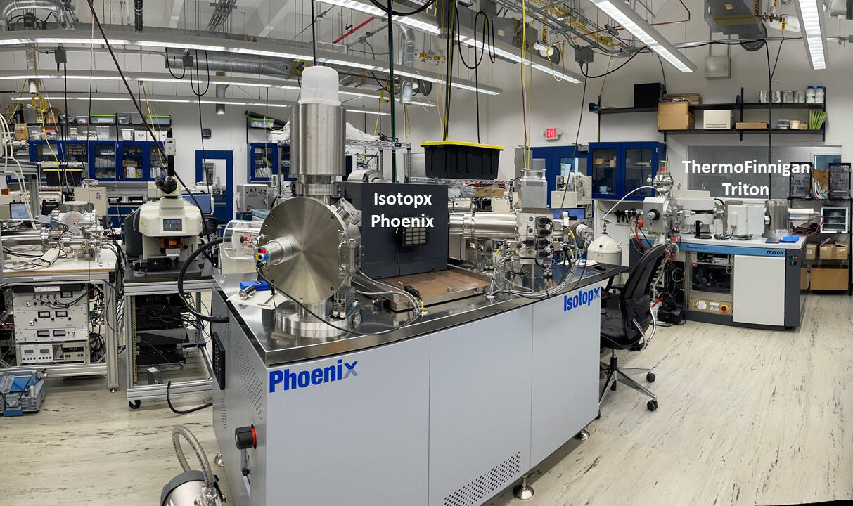
The facility maintains two multi-collector TIMS instruments, including an IsotopX Phoenix (installed July 2017) and Thermo Finnigan Triton (installed 2004). These instruments are capable of running in fully automated modes or remotely through a secured internet connection. Both have moveable faraday cups allowing static or dynamic simultaneous multi-collection of large ion beams. Small ion beams are measured by single-collector peak-hopping methods using either a discrete-dynode electron multiplier or Daly-knob /photomultiplier collector.
Prior to TIMS analyses, chemical processing is required to separate and purify the element of interest. This typically involves acid-digestion and evaporation followed by ion chromatographic exchange on small, resin-filled columns. The clean labs include multiple HEPA-filtered work stations and evaporation boxes that provide class-1000 or better work spaces. As a result, samples are exposed to minimal environmental contamination during processing allowing analyses of very small samples.
Staff
The Denver Radiogenic Isotope Lab is cooperatively run by a number of principle investigators, post-docs, and support staff:
- Adam Hudson (ahudson@usgs.gov): Research Geologist (Principal Investigator), GECSC
- Richard Moscati (rmoscati@usgs.gov): Research Geologist (Principal Investigator), G3SC
- Ryan Frazer (rfrazer@usgs.gov): Research Geologist (Postdoctoral Fellow), GECSC
- Neil Griffis (ngriffis@usgs.gov): Research Geologist (Postdoctoral Fellow), G3SC
- Hannah Tompkins (htompkins@usgs.gov): Geologist (Lab Manager), GECSC
- Miriam Primus (mprimus@usgs.gov): Geologist (USGS Intern), GECSC
- James Paces (jbpaces@usgs.gov): Research Geologist (Emeritus), GECSC
- Leonid Neymark (lneymark@usgs.gov): Research Chemist (Emeritus), G3SC
- Wayne Premo (wpremo@usgs.gov): Geologist (Emeritus), GECSC
Related Content
Strontium and uranium isotopic compositions (87Sr/86Sr and 234U/238U) of mid- to late-Holocene lacustrine sediments from Lower Pahranagat Lake, Pahranagat National Wildlife Refuge, Lincoln County, Nevada
Sr concentrations and 87Sr/86Sr data used to determine the Sr-chronostratigraphic age of sirenian fossils on Santa Rosa Island, Channel Islands National Park, California, USA
Sr-, U-, H- and O-isotope data used to evaluate water sources in the Potrero Creek Wetlands, Upper Santa Cruz Basin, southern Arizona, USA
Data release for Evidence of humans in North America during the Last Glacial Maximum
Uranium- and thorium-isotope data used to estimate uranium-series ages of Pleistocene lake deposits in the Lake Manix basin, Mojave Desert, California
Uranium-, thorium-, strontium-, carbon- and oxygen-isotope data used to evaluate a 300,000-year history of water-table fluctuations at Wind Cave, South Dakota, USA - scale, timing, and groundwater mixing in the Madison Aquifer
Water chemistry data for selected hot springs and rivers in Southwest Yellowstone National Park, Wyoming
Data release for Middle Pleistocene formation of the Rio Grande Gorge, San Luis Valley, south-central Colorado and north-central New Mexico, USA: Process, timing, and downstream implications
U-series isotope data used to date a 130,000-year-old archaeological site in southern California, U.S.A.
Data to accompany U.S. Geological Survey Data Series 1099: Petrographic, geochemical and geochronologic data for Cenozoic volcanic rocks of the Tonopah, Divide, and Goldfield Mining Districts, Nevada
Data Rease for "Isotopic constraints on middle Pleistocene cave evolution, paleohydrologic flow, and environmental conditions from Fitton Cave speleothems, Buffalo National River, Arkansas"
Data Release for Geologic Map of the Fort Collins 30' x 60' quadrangle, Larimer and Jackson Counties, Colorado, and Albany and Laramie Counties, Wyoming
Strontium isotope chronostratigraphic age of a sirenian fossil site on Santa Rosa Island, Channel Islands National Park, California
Central Andean (28–34°S) flood record 0–25 ka from Salinas del Bebedero, Argentina
Evidence for humans in North America during the Last Glacial Maximum
Geomorphic history of Lake Manix, Mojave Desert, California: Evolution of a complex terminal lake basin
Reconstructing paleohydrology in the northwest Great Basin since the last deglaciation using Paisley Caves fish remains (Oregon, U.S.A.)
Dating silica sinter (geyserite): A cautionary tale
Hydrothermal activity in the southwest Yellowstone Plateau Volcanic Field
Middle Pleistocene formation of the Rio Grande Gorge, San Luis Valley, south-central Colorado and north-central New Mexico, USA: Process, timing, and downstream implications
Calcrete uranium deposits in the Southern High Plains, USA
Establishing chronologies for alluvial-fan sequences with analysis of high-resolution topographic data: San Luis Valley, Colorado, USA
Review of the geochemistry and metallogeny of approximately 1.4 Ga granitoid intrusions of the conterminous United States
Miocene−Pleistocene deformation of the Saddle Mountains: Implications for seismic hazard in central Washington, USA
Related Content
- Data
Filter Total Items: 13
Strontium and uranium isotopic compositions (87Sr/86Sr and 234U/238U) of mid- to late-Holocene lacustrine sediments from Lower Pahranagat Lake, Pahranagat National Wildlife Refuge, Lincoln County, Nevada
This data release includes a table of concentrations (Sr, U) and radiogenic-isotope compositions (87Sr/86Sr, 234U/238U) for samples of modern lake water as well as a table of isotopic compositions (87Sr/86Sr and 234U/238U) for carbonate-rich samples from a 12.4-m-long composite core of lacustrine sediment from Lower Pahranagat Lake in southeastern Nevada, USA. Stratigraphic and geochronologic contSr concentrations and 87Sr/86Sr data used to determine the Sr-chronostratigraphic age of sirenian fossils on Santa Rosa Island, Channel Islands National Park, California, USA
This data release includes a table of Sr concentrations and 87Sr/86Sr data used to evaluate primary seawater isotope compositions of marine invertebrate shell material used to estimate the Sr-chronostratigraphic age of sediments hosting early Miocene sirenian fossils on Santa Rosa Island of the Channel Island National Park, Ventura County, CaliforniaSr-, U-, H- and O-isotope data used to evaluate water sources in the Potrero Creek Wetlands, Upper Santa Cruz Basin, southern Arizona, USA
This data release includes a table of 87Sr/86Sr, 234U/238U, δ2H, and δ18O isotope data used to evaluate groundwater- and surface-water-sources contributing to water in perennial wetlands near the mouth of Potrero Creek within the Upper Santa Cruz Basin near Nogales, AZ. Interpretations of those data are discussed in the pamphlet accompanying the USGS Scientific Investigations Map SIM-XXXXXData release for Evidence of humans in North America during the Last Glacial Maximum
Archaeologists and researchers in allied fields have long sought to understand human colonization of North America. Questions remain about when and how people migrated, where they originated, and how their arrival affected the established fauna and landscape. Here, we present evidence from excavated surfaces in White Sands National Park (New Mexico, United States), where multiple in situ human fooUranium- and thorium-isotope data used to estimate uranium-series ages of Pleistocene lake deposits in the Lake Manix basin, Mojave Desert, California
This data release contains numerical U- and Th-isotopic data used to calculate uranium-series age estimates and initial 234U/238U activity ratios for samples of carbonate-rich clast coatings, oncoidal tufa rinds, calcite-replaced rhizoliths, carbonate nodules, and ostracod shells from sites associated with different lake levels of paleo Lake Manix near Barsow, CA. In addition, measured U concentraUranium-, thorium-, strontium-, carbon- and oxygen-isotope data used to evaluate a 300,000-year history of water-table fluctuations at Wind Cave, South Dakota, USA - scale, timing, and groundwater mixing in the Madison Aquifer
Tables of U- and Th-isotopic data used to calculate uranium-series age estimates and initial 234U/238U activity ratios as well as 87Sr/86Sr, delta 13C, and delta 18O for samples of phreatic speleothems from Wind Cave National Park and U- and Sr-isotopic compositions of waters from the southern Black Hills of South Dakota, USAWater chemistry data for selected hot springs and rivers in Southwest Yellowstone National Park, Wyoming
Water analyses are reported for 66 samples collected from numerous thermal and non-thermal (rivers and streams) features in the southwestern areas of Yellowstone National Park (YNP) during 2009, 2017, and 2018. Water samples were collected from sources near Boundary Creek, Bechler River, Falls River, Mountain Ash Creek, Upper Snake River, Spirea Creek, and Lewis Lake. These water samples were collData release for Middle Pleistocene formation of the Rio Grande Gorge, San Luis Valley, south-central Colorado and north-central New Mexico, USA: Process, timing, and downstream implications
This dataset includes tables of 3He-isotopic data used to calculate surface exposure ages for samples of basalt, and U- and Th-isotopic data used to calculate uranium-series age estimates (230Th/U method) and initial 234U/238U activity ratios for samples of pedogenic carbonate formed in soils on alluvial fans in the San Luis Valley, Colorado, USA. These data are included in the publication: RuleU-series isotope data used to date a 130,000-year-old archaeological site in southern California, U.S.A.
Data release for "A 130,000-year-old archaeological site in southern California, U.S.A", published as a Letter to Nature. Includes sample information, U-Th isotope compositions, calculated U-series (230Th/U) ages and initial 234U/238U activity ratios, for mastodon bones from the Cerutti Mastodon site in National City, CA. Formatted data tables can be found in the Supplementary Information associData to accompany U.S. Geological Survey Data Series 1099: Petrographic, geochemical and geochronologic data for Cenozoic volcanic rocks of the Tonopah, Divide, and Goldfield Mining Districts, Nevada
This dataset is the assembled analytical results of geochemical, petrographic, and geochronologic data for samples, principally those of unmineralized Tertiary volcanic rocks, from the Tonopah, Divide, and Goldfield mining districts of west-central Nevada. Much of the data presented here for the Tonopah and Divide districts are for samples collected by Bonham and Garside (1979) during geologic mapData Rease for "Isotopic constraints on middle Pleistocene cave evolution, paleohydrologic flow, and environmental conditions from Fitton Cave speleothems, Buffalo National River, Arkansas"
Data release for "Isotopic constraints on middle Pleistocene cave evolution, paleohydrologic flow, and environmental conditions from Fitton Cave speleothems, Buffalo National River, Arkansas". Extended abstract for the 2017 Karst Interest Group meeting. Includes sample information, U-Th isotope compositions, calculated U-series (230Th/U) ages and initial 234U/238U activity ratios, Sr isotopic coData Release for Geologic Map of the Fort Collins 30' x 60' quadrangle, Larimer and Jackson Counties, Colorado, and Albany and Laramie Counties, Wyoming
This geologic map provides new and compiled geologic mapping at 1:100,000-scale in the Fort Collins 30' x 60' quadrangle covering the northern Front Range and adjacent areas of Colorado. - Publications
Filter Total Items: 26
Strontium isotope chronostratigraphic age of a sirenian fossil site on Santa Rosa Island, Channel Islands National Park, California
Fossils in the order Sirenia (family Dugongidae) from Santa Rosa Island, part of Channel Islands National Park in southern California, provide rare temporal and spatial links between earlier and later evolutionary forms of dugongids, and add information about their dispersal into the northeastern Pacific region. Marine sedimentary rocks containing these fossils have characteristics of both the latAuthorsJames B. Paces, Scott A. Minor, Kevin M. Schmidt, Jonathan HoffmanCentral Andean (28–34°S) flood record 0–25 ka from Salinas del Bebedero, Argentina
The Salinas del Bebedero occupies an isolated basin in the foreland of central Argentina at 33°S and was flooded repeatedly over past 25 ka. Isotopic evidence demonstrates that this flooding was due to overflow of the nearby Río Desaguadero with waters derived from the distant (≥300 km) central Andes between 28–34°S. Stratigraphic and shoreline evidence shows that floods occurred most frequently bAuthorsJay Quade, Elad Dente, Allison Cartwright, Adam M. Hudson, Sebastian Jimenez, David McGeeEvidence for humans in North America during the Last Glacial Maximum
Archaeologists and researchers in allied fields have long sought to understand human colonization of North America. When, how, and from where did people migrate, and what were the consequences of their arrival for the established fauna and landscape are enduring questions. Here, we present evidence from excavated surfaces of in situ human footprints from White Sands National Park (New Mexico, USA)AuthorsMatthew R. Bennett, David Bustos, Jeffrey S. Pigati, Kathleen B. Springer, Thomas. M. Urban, Vance T. Holliday, Sally C. Reynolds, Marcin Budka, Jeffrey S. Honke, Adam M. Hudson, Brendan Fenerty, Clare Connelly, Patrick J. Martinez, Vincent L. Santucci, Daniel OdessGeomorphic history of Lake Manix, Mojave Desert, California: Evolution of a complex terminal lake basin
The US Environmental Protection Agency's short-term freshwater effluent test methods include a fish (Pimephales promelas), a cladoceran (Ceriodaphnia dubia), and a green alga (Raphidocelis subcapitata). There is a recognized need for additional taxa to accompany the three standard species for effluent testing. An appropriate additional taxon is unionid mussels because mussels are widely distributeAuthorsMarith C. Reheis, David M. Miller, James B. Paces, Charles G. Oviatt, Joanna R. Redwine, Darrell Kaufman, Jordon Bright, Elmira WanReconstructing paleohydrology in the northwest Great Basin since the last deglaciation using Paisley Caves fish remains (Oregon, U.S.A.)
The arid northwest Great Basin underwent substantial hydroclimate changes in the past 15,000 years, greatly affecting its desert ecosystems and prehistoric people. There are conflicting interpretations of the timing of hydrologic changes in this region, requiring more records to resolve the dominant climatic drivers. The Paisley Caves archaeological site, located near former pluvial Lake ChewaucanAuthorsAdam M. Hudson, Meaghan M Emery-Wetherell, Patrick M Lubinski, Virginia L. Butler, Deanna N Grimstead, Dennis L JenkinsDating silica sinter (geyserite): A cautionary tale
We describe a new effort to date hydrothermal silica sinter deposits (geyserite) from the Upper Geyser Basin of Yellowstone National Park using 14C of co-deposited organic matter, U-series and cosmogenic 10Be methods. A majority of the samples were collected from stratigraphic sections, mainly at Riverside, Giant, and Castle Geysers. Ages obtained from 41 14C analyses range from modern to 12.1 calAuthorsDakota M. Churchill, Michael Manga, Shaul Hurwitz, Sara Peek, Joseph Licciardi, James B. PacesHydrothermal activity in the southwest Yellowstone Plateau Volcanic Field
In the past two decades, the U.S. Geological Survey and the National Park Service have studied hydrothermal activity across the Yellowstone Plateau Volcanic Field (YPVF) to improve the understanding of the magmatic-hydrothermal system and to provide a baseline for detecting future anomalous activity. In 2017 and 2018 we sampled water and gas over a large area in the southwest YPVF and used LandsatAuthorsShaul Hurwitz, R. Blaine McCleskey, Deborah Bergfeld, Sara Peek, David Susong, David A. Roth, Jefferson Hungerford, Erin B White, Lauren Harrison, Behnaz Hosseini, R. Greg Vaughan, Andrew G. Hunt, James B. PacesMiddle Pleistocene formation of the Rio Grande Gorge, San Luis Valley, south-central Colorado and north-central New Mexico, USA: Process, timing, and downstream implications
The Rio Grande is the fourth longest river in North America extending over 3,000 km from the Rocky Mountains to the Gulf of Mexico. The Pleistocene evolution of this river from individual subbasins into a coalesced fluvial system has been long debated. Herein, we constrain the middle Pleistocene evolution of the northernmost and largest Rio Grande basin, the San Luis basin, and the timing of incisAuthorsChester A. Ruleman, Adam M. Hudson, Ren A. Thompson, Daniel P. Miggins, James B. Paces, Brent M. GoehringCalcrete uranium deposits in the Southern High Plains, USA
The Southern High Plains (SHP) is a new and emerging U.S. uranium province. Here, uranyl vanadates form deposits in Pliocene to Pleistocene sandstone, dolomite, and limestone. Fifteen calcrete uranium occurrences are identified; two of these, the Buzzard Draw and Sulfur Springs Draw deposits, have combined in-place resources estimated at about 4 million pounds of U3O8. Ore minerals carnotite and fAuthorsSusan Hall, Bradley S. Van Gosen, James B. Paces, Robert A. ZielinskiEstablishing chronologies for alluvial-fan sequences with analysis of high-resolution topographic data: San Luis Valley, Colorado, USA
On active alluvial fans, debris-flow deposits and frequent avulsions produce a rough topographic surface. As is the case in many initially rough landforms produced by catastrophic processes, the topography of alluvial fans is progressively smoothed, producing textural differences useful in establishing relative age criteria for fans. Here, we outline an approach for defining a quantitative, numeriAuthorsSamuel Johnstone, Adam M. Hudson, Sylvia Nicovich, Chester A. Ruleman, Robert M. Sare, Ren A. ThompsonReview of the geochemistry and metallogeny of approximately 1.4 Ga granitoid intrusions of the conterminous United States
The conterminous United States hosts numerous volumetrically significant and geographically dispersed granitoid intrusions that range in age from 1.50 to 1.32 billion years before present (Ga). Although previously referred to as A-type granites, most are better described as ferroan granites. These granitoid intrusions are distributed in the northern and central Rocky Mountains, the Southwest, theAuthorsEdward A. du Bray, Christopher S. Holm-Denoma, Karen Lund, Wayne R. PremoMiocene−Pleistocene deformation of the Saddle Mountains: Implications for seismic hazard in central Washington, USA
The Yakima fold province, located in the backarc of the Cascadia subduction zone, is a region of active strain accumulation and deformation distributed across a series of fault-cored folds. The geodetic network in central Washington has been used to interpret large-scale N-S shortening and westward-increasing strain; however, geodetic data are unable to resolve shortening rates across individual sAuthorsLydia M. Staisch, Harvey Kelsey, Brian L. Sherrod, Andreas Möller, James B. Paces, Richard J. Blakely, Richard Styron