
The History of the HIF
A brief history of the Hydrologic Instrumentation Facility and the role it has played in USGS water-resource monitoring and science.
The U.S. Geological Survey (USGS) was established in 1879 by an act of Congress. The new bureau's mission was to "examine the geological structure, mineral resources, and products of the national domain." This mission was expanded in 1888 to include an investigation of the extent to which arid lands in the western United States could be irrigated.
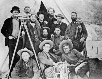
In order to execute this new mission, the USGS developed new methods to gage the flow of streams and trained a group of hydrographers to conduct this work. This initial training involving 14 men and under the direction of F.H. Newell took place at Embudo Station, New Mexico. Embudo Station was a railroad stop along the Rio Grande River and is still there today. At this gage, observations of water level, flow and the weather were made by USGS employees.
Techniques in continuous monitoring and new inventions in the associated equipment were direct results from this early pioneering work. Much of the early work in measuring water levels and water velocity were made with very simple tools. These early instruments, while accurate, were very manpower-intensive and required much vigilance to keep up with necessary maintenance and repairs in order for the instruments to maintain their accuracy.

In the early 1920s, the USGS Cooperative Water Program was started. Federal funds were appropriated by the Federal government to be used by the USGS for hydrologic science. The Cooperative Water Program provided a system of matching funds that scientists could use to work with State and local agencies to collect continuous streamflow data. Typically, the matching funds were (and continue to be) a 50/50 split with the USGS paying half and the cooperating agency paying half of the costs associated with the collection of the data. Thus, the USGS became the principal federal agency responsible for collecting, analyzing and archiving hydrologic data needed to plan, develop, and manage the water resources of the United States.
The USGS office at Columbus, Ohio, played a key role in the development of much of the commonly used equipment we have today. Located on the Ohio State University (OSU) Campus, the Ohio office was given access to the machine shop, foundry, and testing laboratory at the University. Relying heavily on the OSU Department of Industrial Engineering, the USGS developed bridge cranes and trucks, sounding reels, sounding weights (still referred to as "Columbus weights" today), electric tape gage, and the wire weight gage.
After World War II, instrumentation development, which were initially focused on surface water, were expanded to include instrumentation for the measurement of groundwater and water quality.
With support from USGS headquarters in Washington, D.C., the Ohio office continued the development of equipment and, in the mid-1940s, established an equipment laboratory in a building adjacent to the Ohio office. This allowed for an increase the rate at which new equipment could be developed and reduced the reliance on the OSU Engineering Department. This new group was named the Water Resources Branch Equipment Laboratory but was later changed to the Equipment Development Laboratory (EDL).
In the 1950s, a new Instrument Research Unit, later named the Instrument Development Laboratory (IDL), was established to formally recognize the increasing role of electronic technology in USGS water-resource instrumentation. In 1959, the EDL was disbanded and the IDL took over the responsibility for equipment development. In the 1960s, USGS water programs expanded rapidly and the IDL continued to provide instrument support to the USGS.
In 1971, the IDL moved to the Mississippi Test Facility, located north of Bay St. Louis, Mississippi. Many new personnel were added to the staff, and with access to the newly built USGS Hydraulic Laboratory, many advances were made in instrumentation quality and accuracy. The Hydraulic Laboratory consisted of a 450-foot tow tank, a large tilting flume, and jet tank facility in one building and a 4,500-foot floodplain simulation facility (located separately).
In the late 1970s, the Mississippi Test Facility name changed to the National Space Technology Laboratory (NSTL).
In 1980, the USGS Hydrologic Instrumentation Facility (HIF) was established and the IDL became part of this new organizational unit. Through the 1980s and 1990s, many new instruments and improvements to existing equipment were made including a regulator/charger, multiparameter water-quality instrument, and personal field computing software.
The NSTL was renamed the Stennis Space Center after Senator John C. Stennis of Mississippi in the early 1990s.
In 2004, the decision was made to combine the USGS Hydraulic Laboratory and the HIF into one entity. The Hydraulic Laboratory is now part of the HIF's Testing Section.