
August 2022 - Vol. 1 | Issue 3
Great Salt Lake comparison, 1986 and 2022
These Landsat images show the lake at record high levels in 1986 and at a historic low elevation on July 3, 2022. In 1986, the lake was at a record high and covered approximately 2,300 square miles and contained 30 million acre-feet of water (an acre-foot is the amount of water necessary to cover 1 acre of land with water 1 foot in depth or about 326,000 gallons). On July 3, 2022, the level…

Landsat: 50 Years Observing a Changing Earth
For a half-century, the Landsat satellites have revealed patterns of change across our crowded planet. Learn more with this interactive that ESRI and USGS created together.

Landsat Records 50 Years of Growth in Dallas-Fort Worth
Landsat 1 celebrated its 50th anniversary on July 23, 2022!Landsat 1's first satellite image shared with the world was a view of Dallas-Fort Worth, Texas. Over the course of five decades, Landsat satellites have captured the Dallas-Fort Worth area 2033 times, compiled into individual scenes in the Landsat Archive.These false-color Landsat images accentuates the size and growth of the cities. The…
Celebrating Landsat's Golden Anniversary
50 years of teamwork. 50 years of innovation. 50 years of resilience.

Landsat: Helping Us Help Ourselves for 50 Years
We can’t see them, but they’ve faithfully circled above us for 50 years. From hundreds of miles away, Landsat satellites have revealed details and secrets of the Earth’s land that we miss standing on its very surface. They provide information to help us help ourselves, as we fight the risk of threats such as heat waves and wildfires and strive to manage resources like diminishing water supplies.

Fifty Years of Landsat: Impartial Eye on Climate Change
Landsat, a space-based Earth observation program conducted jointly by the U.S. Geological Survey and NASA, celebrates a half century of providing a continuous record of the Earth’s land surfaces during 2022.

Fifty Years of Landsat: Watchman for Wildfires
Earth imagery is fundamental to the USGS fire mission to understand the causes, consequences, and benefits of wildfire. Imagery and data from Landsat satellites also provide information and tools that are widely used for decisions before, during, and after wildfires across the nation. This valuable intel helps prevent and manage larger, catastrophic events.

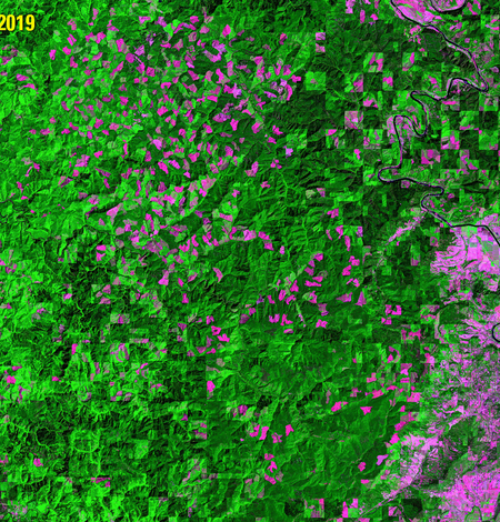
Fifty Years of Landsat: Observing Global Forests from above the Canopy
Around the world, forests provide timber and other wood products, fuel, flood control, biological diversity, recreation, carbon storage and much more. Part Three of our series looks at how freely available Landsat data provides a way for governments and conservation groups to monitor national laws that have been enacted to protect forests.

Fifty Years of Landsat: Observing Earth to Look Forward
On July 23, 2022, Landsat—a space-based Earth observation program conducted jointly by the U.S. Geological Survey and NASA—marks a half century of providing a continuous record of the Earth’s land surfaces. Landsat’s fifty-year archive of Earth observation supplies the world with an unparalleled baseline of trusted, empirical evidence to support a shared understanding of how the Earth is changing.
Special Issue: Landsat Update 50th Anniversary
Landsat Updates are prepared periodically and distributed electronically to provide information about Landsat activities and related topics of interest.

Fifty Years of Landsat: Sharing Earth information for the benefit of all
In 2022, the Landsat series of satellites, a program conducted jointly by the U.S. Geological Survey and NASA, celebrates a half century of worldwide Earth observations for the good of humankind.

Eyes on Earth Episode 78 – Landsat 50 Lookback
Eyes on Earth is a podcast on remote sensing, Earth observation, land change and science, brought to you by the USGS Earth Resources Observation and Science (EROS) Center. In this episode, we look back at how past guests viewed the value of Landsat satellites and their 50-year history.