
Latest in Landsat - June 2024 - Vol. 3 | Issue 6

USGS EROS Director Joining NASA, NOAA, Australia on GEOINT Landsat Panel
The GEOINT 2024 Symposium taking place May 5-8, 2024, in Florida features a Government Hub panel discussion on the Landsat 2030 Initiative that includes Pete Doucette, Director of the U.S. Geological Survey Earth Resources Observation and Science (EROS) Center.
USGS Staff Present at Natural Disasters Response Workshop
Landsat Imagery continue to be reliable resource

Eyes on Earth Episode 119 – Kristi Kline: EROS Career Reflections
In this episode of Eyes on Earth, we talk with Kristi Kline about the constant changes and innovations that have been needed at EROS to keep up with changes in computer tech and data processing. Kline has been a part of helping to implement these changes over the past 27 years and is now retiring at the end of May 2024. We discuss her favorite memories like attending the Landsat 8 launch, and…

How Do You Landsat
This story contains examples of regional and global projects that utilize Landsat data to assist policymakers and land managers in making informed decisions about our environment and Earth’s natural resources.

Connect
Access the information on this page to learn more about Landsat, access our social media platforms, or contact us with questions you have about the Landsat missions, the available science products, and how to access Landsat data!
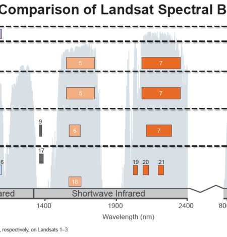
Spectral Bandpasses for all Landsat Sensors
This image shows the spectral bandpasses for the sensors on all Landsat satellites. Landsat 1-5 Multispectral Scanner System (MSS)*: the sensor onboard each satellite acquired data in four spectral bands in the visible and near infrared spectrumsLandsat 4 and Landsat 5 Thematic Mapper (TM): the sensor onboard each satellite acquired data in seven spectral bands, and included shortwave infrared…

Earthshots
The surface of the Earth is always changing. Some changes like earthquakes, volcanoes, floods, and landslides happen quickly, and other changes, such as most erosional processes, happen slowly over time. It’s often hard to see these changes from ground level. Earthshots shows you how satellite data are used to track these changes over time.

Landsat Frequently Asked Questions
This page lists commonly asked questions pertaining to the Landsat satellite missions, the science behind maintaining high quality Landsat data, and what products are available - and how to download them.