
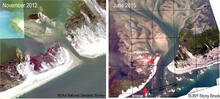
Aerial images of the wilderness breach
By St. Petersburg Coastal and Marine Science Center
2015 (approx.)

Detailed Description
Aerial images of the wilderness breach: a) Aerial photograph taken several days after Hurricane Sandy (photo credit: NOAA); b) Aerial mosaic of the breach in June 2015 showing the location of erosion on the ocean side of the breach and deposition that results in the seasonal formation of a spit (photo credit: Stonybrook University).
Sources/Usage
Public Domain.