
Airborne geophysical survey area in northeast Wisconsin

Detailed Description
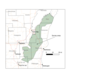
This map shows the airborne geophysical survey area in northeast Wisconsin. Surveys will be conducted along a grid of lines within the green shaded area. Flights will not occur directly over populated areas. Planned flight lines and survey progress can be found online. (USGS map)
Sources/Usage
Public Domain.