
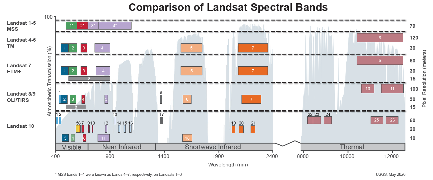
Spectral Bandpasses for all Landsat Sensors

Detailed Description
This image shows the spectral bandpasses for the sensors on all Landsat satellites.
- Landsat 1-5 Multispectral Scanner System (MSS)*: the sensor onboard each satellite acquired data in four spectral bands in the visible and near infrared spectrums
- Landsat 4 and Landsat 5 Thematic Mapper (TM): the sensor onboard each satellite acquired data in seven spectral bands, and included shortwave infrared and thermal data
- Landsat 7 Enhanced Thematic Mapper Plus (ETM+): acquired data in a total of eight spectral bands, including a 15-meter panchromatic band
- Landsat 8 and Landsat 9 Operational Land Imager (OLI) and the Thermal Infrared Sensor (TIRS): the sensors onboard each satellite acquire data in a total of eleven bands, including:
- Band 1 – “Coastal / Aerosol Band”: helps scientists measure ocean color in coastal regions and is also useful for aerosol detection
- Band 9 – “Cirrus Band”: For measuring light in the part of the electromagnetic spectrum where the clouds are most visible for enhanced cloud and shadow detection
- Bands 10 and 11 thermal bands for measuring thermal infrared radiation
- The Landsat 10 26-band “superspectral” instrument suite will support improved monitoring of water quality, agriculture, vegetation health, snow and ice, soil conditions, and other environmental parameters. Landsat 10 is expected to launch in 2031.
*Landsat MSS = the numbers shown are for Landsat 4 and Landsat 5; Landsat 1-3 band numbers are 4, 5, 6 and 7.
Sources/Usage
Public Domain.
Related

What are the band designations for the Landsat satellites? What are the band designations for the Landsat satellites?
The sensors carried on the Landsat satellites acquired data in different wavelengths within the electromagnetic spectrum. Technological advancements have drastically improved the data collected since 1972: The Multispectral Scanner (MSS) carried on Landsat 1,2,3,4 and 5 collected data in four ranges (bands). The Thematic Mapper (TM) sensor on Landsat 4 and Landsat 5 included bands in the same...
Related
What are the band designations for the Landsat satellites? What are the band designations for the Landsat satellites?
The sensors carried on the Landsat satellites acquired data in different wavelengths within the electromagnetic spectrum. Technological advancements have drastically improved the data collected since 1972: The Multispectral Scanner (MSS) carried on Landsat 1,2,3,4 and 5 collected data in four ranges (bands). The Thematic Mapper (TM) sensor on Landsat 4 and Landsat 5 included bands in the same...