
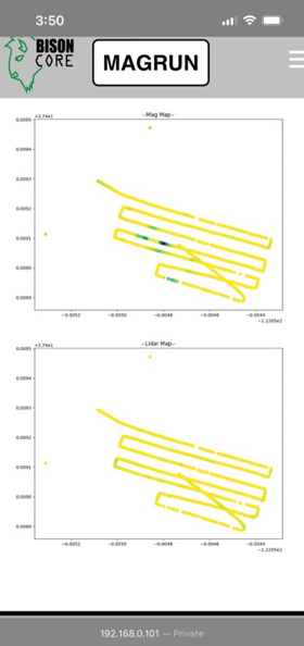
BisonCore (MagEdition) displays live magnetic data (top) and lidar altitude (bottom)
Detailed Description
USGS National Innovation Center UAS Research Center Saucer Shark Project, BisonCore displays the path of the sensor live, as it covers transects. Data received from the payload is then displayed within the BisonCore Ecosystem and is accessible for field viewing. The magnetic map is also used to validate payload directed algorithms.
Sources/Usage
Public Domain.
Related

Saucer Shark Project
The Saucer Shark is a Magnetometer Payload suspended below an uncrewed aerial vehicle (UAV) to reduce platform induced magnetic noise while maintaining high sensitivity. This payload is an evolution in the geomagnetic sensing realm; boasting a high and adjustable sampling rate, low noise, ease of portability (additionally used as a walking ground survey), real-time data downlink, user interface...
Related
Saucer Shark Project
The Saucer Shark is a Magnetometer Payload suspended below an uncrewed aerial vehicle (UAV) to reduce platform induced magnetic noise while maintaining high sensitivity. This payload is an evolution in the geomagnetic sensing realm; boasting a high and adjustable sampling rate, low noise, ease of portability (additionally used as a walking ground survey), real-time data downlink, user interface...