
Coast Cam at the USACE Field Research Facility

Detailed Description
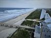
USGS scientists mounted this high-resolution digital camera on an observation tower in the dune at the U.S. Army Corps of Engineers Field Research Facility near Kitty Hawk, North Carolina. The camera overlooks the beach, dune, and an instrument array, and collects images throughout calm and storm conditions.
Images will be used to measure wave runup at the shoreline and estimate storm-induced total water levels, estimate the magnitude of sand eroded or accreted along the transect, provide insight into the observed elevation changes, help validate numerical models, and measure the beach topographic profile hourly to observe how changes in the water levels impact the beach slope/profile and in turn how the beach profile shape influences the waves and water levels throughout a storm.
These images are being collected as part of the are part of the DUring Nearshore Event eXperiment (DUNEX) project on the Outer Banks. DUNEX is a multi-agency, academic, and non-governmental organization collaborative community experiment designed to study nearshore coastal processes during storm events. USGS' participation in DUNEX will contribute new measurements and models that will increase our understanding of storm impacts to coastal environments, including hazards to humans and infrastructure and changes in landscape and natural habitats.
Sources/Usage
Public Domain.