
Collecting beach profile data with GPS

Detailed Description
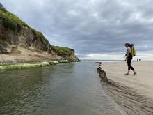
A USGS scientist walks along Santa Cruz Main Beach at the edge of the San Lorenzo River in Santa Cruz, California, wearing a backpack with GPS equipment. She is collecting elevation data that will be used to create a topographic map of the beach. This mapping effort is part of recurring surveys in the Monterey Bay area. Data from these surveys help the USGS understand how sand moves around the Bay, how the beaches, inlets, harbors, and other coastal features change with storms and the seasons, and how the local community may be impacted.
Sources/Usage
Public Domain.