
Columbia River estuary

Detailed Description
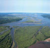
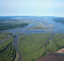
Photograph showing view of lower Columbia River estuary, approximately 55 kilometers from the mouth, looking down-estuary with Welch Island in the foreground; the ocean entrance in the background.
Sources/Usage
Public Domain.
Columbia River Estuary Ecosystem Classification—Concept and Application, U.S. Geological Survey Open-File Report 2011-1228
Prepared in cooperation with the University of Washington and the Lower Columbia River Estuary Partnership
Citation: Simenstad, C.A., Burke, J.L., O'Connor, J.E., Cannon, C., Heatwole, D.W., Ramirez, M.F., Waite, I.R., Counihan, T.D., and Jones, K.L., 2011, Columbia River Estuary ecosystem classification—Concept and application: U.S. Geological Survey Open-File Report 2011-1228, i-54 p., doi: 10.3133/ofr20111228.