
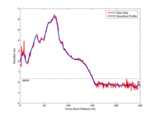
Cross-section of lidar data is extracted from the survey

Detailed Description
A cross-section of lidar data is extracted from the survey, creating a profile view of the beach and dune. In order to eliminate small variations in elevation, the profile is mathematically smoothed.
Sources/Usage
Public Domain.
Related

Storm-Impact Scale
The potential vulnerability of a particular stretch of coast can be assessed using a conceptual model that scales the impacts of storms on barrier islands.
Related
Storm-Impact Scale
The potential vulnerability of a particular stretch of coast can be assessed using a conceptual model that scales the impacts of storms on barrier islands.