
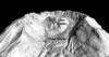
DEM of Mount St. Helens' Crater Glacier and lava domes
By Volcano Hazards Program
1905 (approx.)

Detailed Description
Image of Mount St. Helens lava domes and Crater Glacier on October 1, 2012. The image was created from 1:12,000 scale vertical aerial photographs combined with ground control points from campaign GPS and targets. Photogrammetry software was used to collect a 3-D point cloud and combined to make this digital elevation model (DEM) focusing on the volcano's crater.
Sources/Usage
Public Domain.