
Digital elevation model of the bed and banks CO River
By Southwest Biological Science Center
2009 (approx.)

Detailed Description
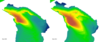
Perspective view of digital elevation model of the bed and banks of the Colorado River about 44 miles downstream from Lees Ferry, Arizona. Between 2009 and 2012, it is possible to see erosion of sediment from the bed of the river in the channel and erosion of sediment from the sandbar on the bank. The direction of streamflow is from the upper left to lower right and the river is about 450 feet wide at the widest point in this view.
Sources/Usage
Public Domain.