
Evolution of a Realime Landslide Map

Detailed Description
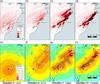
(a–d) Evolution of landslide map with (e–h) four major updates to the USGS ShakeMap, in which the ShakeMap version and release time relative to the earthquake time are labeled below each map; the star indicates the epicenter; triangles and circles show seismic and “Did You Feel It?” data; and polygons show fault segments used in each version of the ShakeMap.
Sources/Usage
Public Domain.
Near Realtime Maps of Possible Earthquake-Triggered Landslides
Science for Everyone web article