
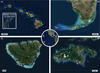
Figure 3 from coral reef “oases”

Detailed Description
Maps showing the four focal regions used for this study: (a) main Hawaiian Islands, (b) Florida Keys, (c) Mo'orea, French Polynesia, and (d) St. John, US Virgin Islands. Circles marking sites are colour coded and sized based on their median z‐scores, with increasing diameters of symbols denoting increasing median z‐scores. Image credits: Esri, DigitalGlobe, GeoEye, i‐cubed, USDA FSA, USGS, AEX, Getmapping, Aerogrid, IGN, IGP, swisstopo, GIS user community