
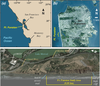
Fort Funston Location Maps

Detailed Description
Maps of the Fort Funston, California study area, including (a) regional perspective and (b) local maps. (c) Oblique shaded-relief map of the Fort Funston study area showing the half-mile length of cliffs between the beach access trail in the north and the end of the high cliff in the south. Also shown is the Oceanside Wastewater Treatment Plant (OWTP). Imagery from (b) NASA and (c) Google Earth.