
Georgia Agricultural Water Conservation and Metering-Irrigation Trends
Detailed Description
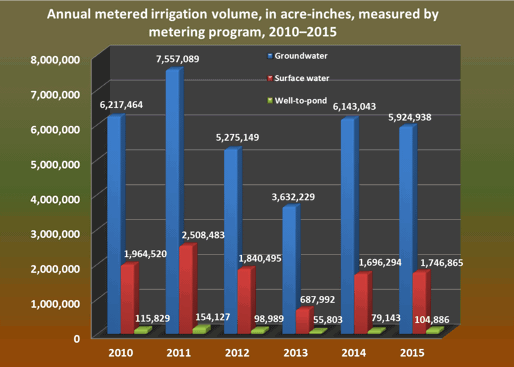
The Georgia Soil and Water Conservation Commission (Commission) monitored rates and volumes of agricultural irrigation supplied by groundwater, surface-water, and well-to-pond sources in southern Georgia using a network of more than 10,000 annually read flow meters and about 200 daily reporting, satellite-transmitted, telemetry sites. Through Georgia General Assembly House Bill 579, enacted on June 4, 2003, the Commission received legislative authority to "[implement] a program of measuring farm uses of water in order to obtain clear and accurate information on the patterns and amounts of such use, which information is essential to proper management of water resources by the state and useful to farms for improving the efficiency and effectiveness of their use of water … and [for] improving water conservation" (Georgia General Assembly). Since November 2008, the U.S. Geological Survey in cooperation with the Commission has investigated methods to estimate agricultural water use and growing season pumping rates through the analysis of water-meter data. This web site presents results of this cooperative investigation of agricultural water use in the middle-and-lower Chattahoochee and Flint River basin and its subbasins and a summary analysis in the lower Ocmulgee River subbasin.