
Gulf of Maine stations sampled

Detailed Description
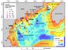
Stations sampled for erosion analysis (black squares) and concentration of A. fundyense cysts in 0-1 cm interval of surface sediment for 2011 (pink circles). Grand Manan (GM), eastern Maine shelf (EMS), central Maine shelf (CMS), western Maine shelf (WMS), central Maine seed bed (CMSB), Jordan Basin (JB), and Wilkinson Basin (WB). Samples obtained at the cyst-map stations were analyzed for cyst concentration (0-1 cm and 1-3 cm intervals) and sediment texture (0-3 cm interval). Multiple samples with the Craib corer were obtained at stations 43, CMSB, and GM. The largest cyst concentrations are in the Bay of Fundy east of Grand Manan Island (GM); south of Penobscot Bay (CMSB); and southwest along the western Maine and New Hampshire coasts.
Sources/Usage
Public Domain.