
Hurricane Florence Modeling
By Woods Hole Coastal and Marine Science Center
2018 (approx.)

Detailed Description
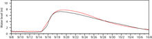
Streamflow on land is modeled with the hydrological model and then coupled with the ocean model. This figure shows comparison of water level between observed data (red) and a smoothed model output at the North East Cape Fear River.
Sources/Usage
Courtesy of Daoyang Bao, Louisiana State University