
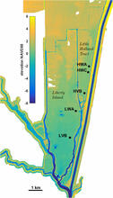
Instrument locations in Little Holland Tract and Liberty Island

Detailed Description
Map shows elevation and bathymetry of a portion of the Sacramento-San Joaquin Delta where instruments were placed, to collect time series of water surface elevation, wave height and period, turbidity, current velocity, and wave velocity.
Sources/Usage
Public Domain.
USGS Data Release
Wind-wave and suspended-sediment data from Liberty Island and Little Holland Tract, Sacramento-San Joaquin Delta, California