



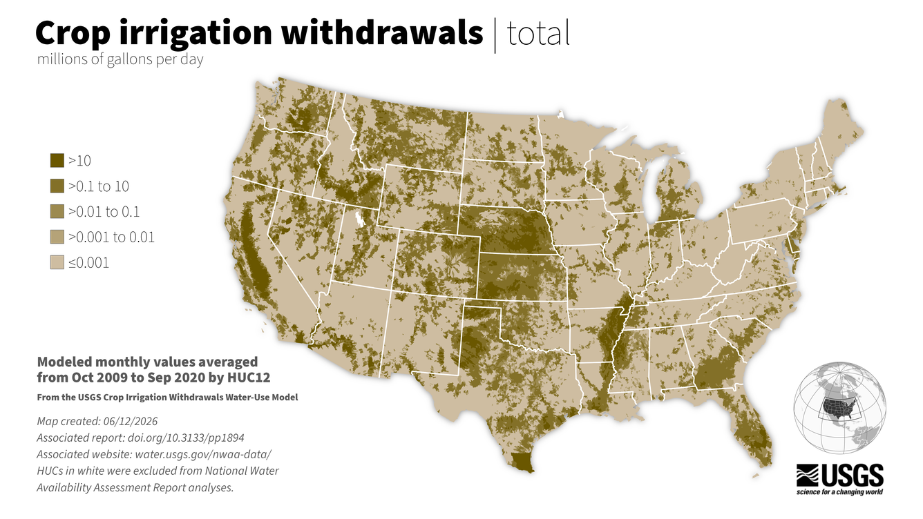
Irrigation Water Use map, monthly averages 2009-2020 by watershed


Detailed Description
This model computes the amount of crop irrigation withdrawals each month over the period from 2000 to 2020 for all subwatersheds (12-digit Hydrologic Unit Codes or HUC12s) in the conterminous United States (CONUS).
Crop irrigation withdrawals refer to water removed from a groundwater or surface-water source to produce agricultural crops. In this model, crop irrigation withdrawals are calculated by combining modeled irrigation consumptive use, irrigation efficiencies, and source-water proportions.
Published through the National Water Availability Assessment Data Companion.
Sources/Usage
Public Domain.
Related

Irrigation Water Use
Throughout the world, irrigation (water for agriculture) is essential for keeping fruits, vegetables, and grains growing to feed the world's population. In addition, irrigation can alleviate crop stress from droughts, decrease soil erosion, and can reduce water pollution. USGS scientists provide estimates of irrigation water use to help water managers make informed decisions.

Accessing Water Use Data
The USGS provides historic and recent water use data for the United States including the District of Columbia, Puerto Rico, and the U.S. Virgin Islands. This page provides an up-to-date guide to accessing, downloading, and using USGS water use data.

Water Use in the United States
Since 1950, the USGS has regularly produced nationwide water‑use data, creating one of the most comprehensive pictures of how water is used across the United States. Building on this rich historical record, these data give water managers a critical foundation to evaluate long‑term trends, plan strategically, and identify and quantify water availability so they can design more adaptive, resilient...

National Water Availability Assessments
The USGS National Water Availability Assessment consists of reports, which provide a scientific summary and interpretation of water quantity, quality and use, and the data companion, which delivers model-based estimates of water supply and demand.
National Water Availability Assessment: Key Findings
This interactive website highlights the top scientific findings of the National Water Availability Assessment report through engaging stories, plain-language explanations, and interactive data visualizations.

National Water Availability Assessment Reports
The National Water Availability Assessment reports provide synthesis and interpretation of water availability in the past, present, and future.

National Water Availability Assessment Data Companion
The National Water Availability Assessment Data Companion (NWDC) delivers model-based estimates of water supply and demand.
Related
Irrigation Water Use
Throughout the world, irrigation (water for agriculture) is essential for keeping fruits, vegetables, and grains growing to feed the world's population. In addition, irrigation can alleviate crop stress from droughts, decrease soil erosion, and can reduce water pollution. USGS scientists provide estimates of irrigation water use to help water managers make informed decisions.
Accessing Water Use Data
The USGS provides historic and recent water use data for the United States including the District of Columbia, Puerto Rico, and the U.S. Virgin Islands. This page provides an up-to-date guide to accessing, downloading, and using USGS water use data.
Water Use in the United States
Since 1950, the USGS has regularly produced nationwide water‑use data, creating one of the most comprehensive pictures of how water is used across the United States. Building on this rich historical record, these data give water managers a critical foundation to evaluate long‑term trends, plan strategically, and identify and quantify water availability so they can design more adaptive, resilient...
National Water Availability Assessments
The USGS National Water Availability Assessment consists of reports, which provide a scientific summary and interpretation of water quantity, quality and use, and the data companion, which delivers model-based estimates of water supply and demand.
National Water Availability Assessment: Key Findings
This interactive website highlights the top scientific findings of the National Water Availability Assessment report through engaging stories, plain-language explanations, and interactive data visualizations.
National Water Availability Assessment Reports
The National Water Availability Assessment reports provide synthesis and interpretation of water availability in the past, present, and future.
National Water Availability Assessment Data Companion
The National Water Availability Assessment Data Companion (NWDC) delivers model-based estimates of water supply and demand.