
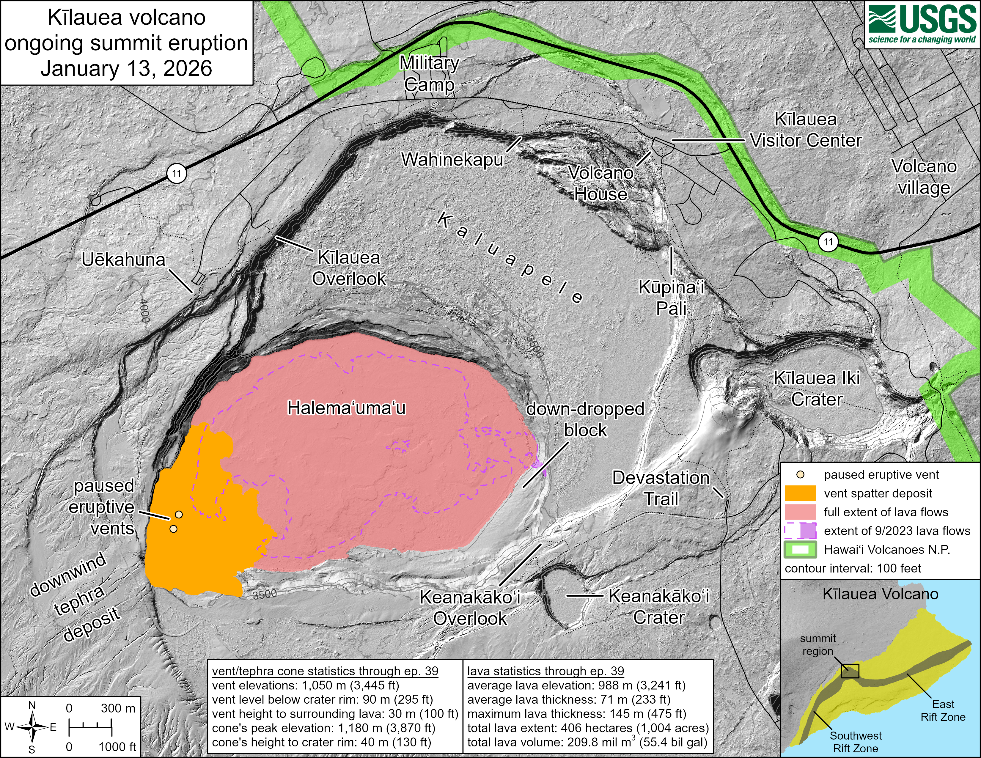
January 13, 2026—Kīlauea summit eruption reference map

Detailed Description
This reference map depicts the Kīlauea summit eruption within Halema‘uma‘u crater that began on December 23, 2024. The data for this map were collected during a Hawaiian Volcano Observatory helicopter overflight on January 2, 2026; as such, the provided statistics are reflective of the first thirty-nine episodes of the eruption through December 24, 2025. A fortieth lava fountaining episode occurred yesterday, January 12, but its lava flows have not yet been fully mapped at this time.
Eruptive vent and tephra cone statistics through episode 39:
- Vent elevations: 1,050 meters (3,445 feet)
- Vent level below crater rim: 90 meters (295 feet)
- Vent height to surrounding lava: 30 meters (100 feet)
- Cone's peak elevation: 1,180 meters (3,870 feet)
- Cone's height to crater rim: 40 meters (130 feet)
Lava statistics through episode 39:
- Average lava elevation: 988 meters (3,241 feet)
- Average lava thickness: 71 meters (233 feet)
- Maximum lava thickness: 145 meters (475 feet)
- Total lava extent: 406 hectares (1,004 acres)
- Total lava volume: 209.8 million cubic meters (55.4 billion gallons)
Note that the map shows a significant expansion of the vent spatter deposit, which is the result of more comprehensive mapping of the episode 38 deposit in the southwest corner of Halema‘uma‘u. Additionally, the provided eruption statistics indicate a maximum lava thickness lower than that in previous maps; reanalysis of earlier overflight data showed that thickness measures near the eruptive vents were affected by the emitted volcanic gas plume. This has now been corrected for, and the new maximum lava thickness value should be considered more accurate at present.
Sources/Usage
Public Domain.