
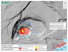
January 25, 2021—Kīlauea summit eruption contour map
By Kīlauea

Detailed Description
This map of Halema‘uma‘u at the summit of Kīlauea shows 20 m (66 ft) contour lines (dark gray) that mark locations of equal elevation above sea level (asl). The map shows that the lava lake (approximate active area marked in red) has filled 205 m (673 ft) of Halema‘uma‘u since the eruption began at approximately 9:30 p.m. HST on December 20, 2020. USGS map.
Sources/Usage
Public Domain.