
Kīlauea caldera gas mapping - July 28, 2021 — Kīlauea

Detailed Description
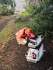
A USGS scientist calibrates two MultiGas instruments to prepare for mapping volcanic gasses on the floor of Kīlauea caldera. With the MultiGas strapped to metal backpack frames, the scientists traverse across the caldera floor to collect gas data which will be compared to the last survey. These instruments measure the concentrations of carbon dioxide (CO2), sulfur dioxide (SO2), hydrogen sulfide (H2S), and water vapor (H2O) that are emitted. USGS photo taken by L. DeSmither on July 28, 2021.
Sources/Usage
Public Domain.