
Land Surface Position, Cuyama Valley, CA

Detailed Description
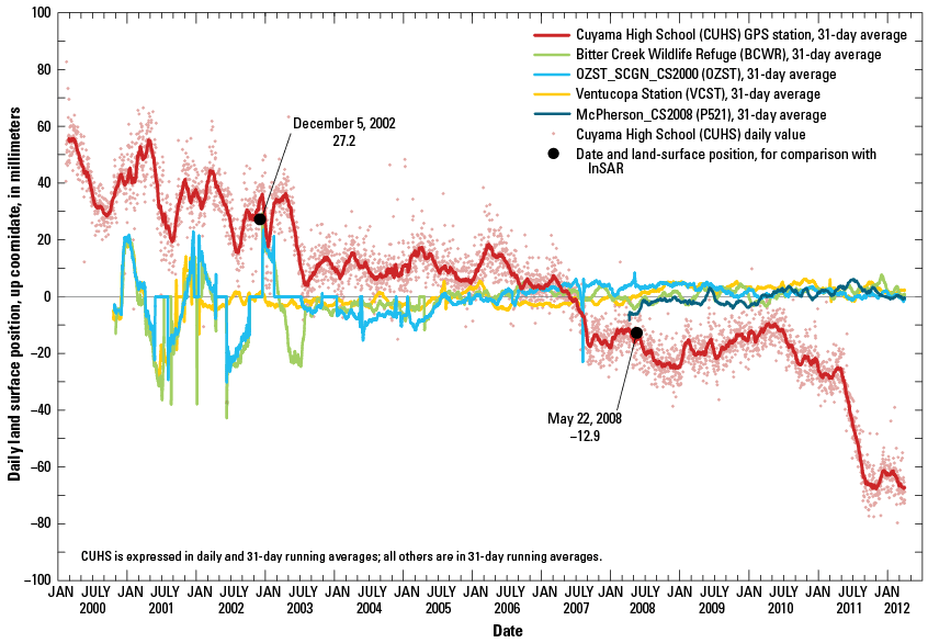
Land-surface position, up coordinate, in millimeters, for the GPS stations Cuyama High School (CUHS), Ventucopa Station (VCST), McPherson_CS2008 (P521), Bitter Creek Wildlife Refuge (BCWR), and OZST_SCGN_CS2000 (OZST), Cuyama Valley, Santa Barbara County, California. The measured displacement at CUHS between December 5, 2002, and May 22, 2008, was -40 mm. It is likely that this downward trend, or subsidence, represents inelastic deformation and indicates compaction and reduced storage capacity of the aquifer sediments; a significant component ofthe seasonal fluctuations represented elastic deformation, as evidenced by various periods of partial recovery.
Sources/Usage
Related

Simulating Land Subsidence
The California Water Science Center has been involved in multiple studies simulating land subsidence associated with groundwater withdrawal. The simulations can be used to estimate the magnitude, location, and timing of subsidence. They can also be used to evaluate management strategies to mitigate adverse effects from subsidence while also optimizing water availability.
Related
Simulating Land Subsidence
The California Water Science Center has been involved in multiple studies simulating land subsidence associated with groundwater withdrawal. The simulations can be used to estimate the magnitude, location, and timing of subsidence. They can also be used to evaluate management strategies to mitigate adverse effects from subsidence while also optimizing water availability.