
Landsat 9 Underfly with Landsat 8 Illustration

Detailed Description
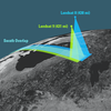
This illustration shows how tandem imagery are acquired by both satellites during an underfly opportunity. After its launch on September 27, 2021, Landsat 9 flew beneath Landsat 8 as the satellite continued its climb to nominal orbital altitude. The underfly allowed calibration experts to compare measurements collected by the instruments on both satellites to ensure data quality continuity. This tandem collection opportunity extended to about 5 days, collecting 2,396 images from November 12-16, 2021, with 100 percent overlap between the two satellites on November 14th.
Visit the Landsat Mission Underfly Opportunities webpage for more details about satellite underfly activities.
Sources/Usage
Public Domain.