
Landsat 9 image of Bangladesh Coast

Detailed Description
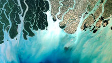
Landsat 9 natural color image (Bands 4, 3, 2) of the Bangladesh coastline on the Bay of Bengal acquired on February 8, 2022. The Sundarbans mangrove forest, a protected UNESCO area, appears as dark green on the left side of the image. The right side of the image shows agricultural lands and urban areas as light tan and gray. Between Landsat 8 and Landsat 9, the Landsat program delivers complete coverage of the Earth’s surface every eight days.
Landsat Scene ID LC09_L1TP_137045_20220208_20220208_02_T1
Sources/Usage
Public Domain.