
Landsat 9 Image of Prudhoe Bay, Alaska

Detailed Description
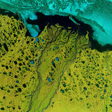
In Alaska, the Sagavanirktok River flows North to empty in Beaufort Sea near Prudhoe Bay. Landsat 9 captured this false color image on July 1, 2022, using Bands 6|5|4.
This frozen tundra climate lies above the Arctic Circle. Summer brings the midnight sun continuously for a few weeks; comparably, the frigid winters experience the opposite with weeks with twenty-four hours of darkness.
Above the thick, frozen soil, unpredictable lakes and waterways are in constant flux. Observable factors like precipitation, evaporation, and snowmelt runoff are common. More erratic changes like permafrost melt are invisible to the human eye. Using Landsat satellites, scientists can study changes across the Arctic area.
Learn more about the Landsat Program at https://www.usgs.gov/landsat-missions
Sources/Usage
Public Domain.