
Lava Lake Depth March 4th
By Kīlauea

Detailed Description
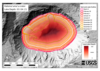
Data from a Kīlauea summit helicopter overflight on March 4th allowed for the calculation of the depth of the lava in Halema‘uma‘u crater. The deepest parts of the lake (darkest reds) exceed 200 meters (650 feet). Different-colored lines in Halema‘uma‘u show the perimeter of the lava lake and the vents over the course of the eruption. Rise of the lava lake has slowed in recent weeks as the eruption rate has decreased and the crater diameter has increased. The basemap is a pre-eruption DEM from 2019. The map is oriented with North towards the top.
Sources/Usage
Public Domain.