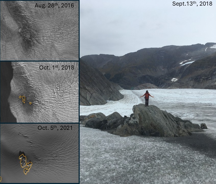
Lemon Creek Glacier - bedrock emergence
By Alaska Science Center
2018 (approx.)
Detailed Description
Time series of satellite imagery (left) illustrates the progressive emergence of a rocky outcrop from the surface of Lemon Creek Glacier between 2016 and 2021. A debris band visible for many years prior to 2016, marks the feature’s position beneath thinning ice. By October 2018 (orange outline), the rock first became exposed, and by 2021 it has expanded substantially. The field photograph (right) shows a researcher ground-truthing the feature shortly after emergence.
Sources/Usage
Public Domain.
Related
Glaciers and Landscape Change
Mountain glaciers are dynamic reservoirs of frozen water, deeply interconnected with their surrounding ecosystems. Glacier change in North America has major societal impacts, including to water resources, natural hazard risk, tourism disruption, fisheries, and global sea level change. Understanding and quantifying precise connections between changing glaciers, the surrounding landscape and climate...
Geodetic Data for USGS Glaciers: Orthophotos, Digital Elevation Models, Glacier Boundaries and Surveyed Positions Geodetic Data for USGS Glaciers: Orthophotos, Digital Elevation Models, Glacier Boundaries and Surveyed Positions
This data release provides geodetic measurements collected since the mid-1940s to characterize the surface elevation, area, and motion of glaciers studied by the U.S, Geological Survey. The primary glaciers of focus are the Benchmark Glaciers of North America which include Gulkana, Wolverine, and Lemon Creek Glaciers in Alaska, Sperry Glacier in Montana, and South Cascade Glacier in...
Compiled Input Data and Glacier-Wide Mass Balances Compiled Input Data and Glacier-Wide Mass Balances
This data release includes compiled input data and glacier-wide mass balance data collected on various North American glaciers under various projects and funding sources. Vocabulary used is defined herein and follows Cogley and others (2011) Glossary of Glacier Mass Balance. Input data are of three types: 1) time-variable area altitude distribution (AAD); 2) time series of point mass...
Accelerating glacier volume loss on Juneau Icefield driven by hypsometry and melt-accelerating feedbacks Accelerating glacier volume loss on Juneau Icefield driven by hypsometry and melt-accelerating feedbacks
Globally, glaciers and icefields contribute significantly to sea level rise. Here we show that ice loss from Juneau Icefield, a plateau icefield in Alaska, accelerated after 2005 AD. Rates of area shrinkage were 5 times faster from 2015–2019 than from 1979–1990. Glacier volume loss remained fairly consistent (0.65–1.01 km3 a−1) from 1770–1979 AD, rising to 3.08–3.72 km3 a−1 from 1979...
Authors
Bethan Davies, Robert McNabb, Jacob Bendle, Jonathan L. Carrivick, Jeremy Ely, Tom Holt, Bradley Markle, Christopher J. McNeil, Lindsey Nicholson, Mauri Pelto
Explaining mass balance and retreat dichotomies at Taku and Lemon Creek Glaciers, Alaska Explaining mass balance and retreat dichotomies at Taku and Lemon Creek Glaciers, Alaska
We reanalyzed mass balance records at Taku and Lemon Creek Glaciers to better understand the relative roles of hypsometry, local climate and dynamics as mass balance drivers. Over the 1946–2018 period, the cumulative mass balances diverged. Tidewater Taku Glacier advanced and gained mass at an average rate of +0.25±0.28 m w.e. a–1, contrasting with retreat and mass loss of –0.60±0.15 m w...
Authors
Christopher J. McNeil, Shad O’Neel, Michael Loso, Mauri Pelto, Louis C. Sass, Emily Baker, Seth Campbell
Related
Glaciers and Landscape Change
Mountain glaciers are dynamic reservoirs of frozen water, deeply interconnected with their surrounding ecosystems. Glacier change in North America has major societal impacts, including to water resources, natural hazard risk, tourism disruption, fisheries, and global sea level change. Understanding and quantifying precise connections between changing glaciers, the surrounding landscape and climate...
Geodetic Data for USGS Glaciers: Orthophotos, Digital Elevation Models, Glacier Boundaries and Surveyed Positions Geodetic Data for USGS Glaciers: Orthophotos, Digital Elevation Models, Glacier Boundaries and Surveyed Positions
This data release provides geodetic measurements collected since the mid-1940s to characterize the surface elevation, area, and motion of glaciers studied by the U.S, Geological Survey. The primary glaciers of focus are the Benchmark Glaciers of North America which include Gulkana, Wolverine, and Lemon Creek Glaciers in Alaska, Sperry Glacier in Montana, and South Cascade Glacier in...
Compiled Input Data and Glacier-Wide Mass Balances Compiled Input Data and Glacier-Wide Mass Balances
This data release includes compiled input data and glacier-wide mass balance data collected on various North American glaciers under various projects and funding sources. Vocabulary used is defined herein and follows Cogley and others (2011) Glossary of Glacier Mass Balance. Input data are of three types: 1) time-variable area altitude distribution (AAD); 2) time series of point mass...
Accelerating glacier volume loss on Juneau Icefield driven by hypsometry and melt-accelerating feedbacks Accelerating glacier volume loss on Juneau Icefield driven by hypsometry and melt-accelerating feedbacks
Globally, glaciers and icefields contribute significantly to sea level rise. Here we show that ice loss from Juneau Icefield, a plateau icefield in Alaska, accelerated after 2005 AD. Rates of area shrinkage were 5 times faster from 2015–2019 than from 1979–1990. Glacier volume loss remained fairly consistent (0.65–1.01 km3 a−1) from 1770–1979 AD, rising to 3.08–3.72 km3 a−1 from 1979...
Authors
Bethan Davies, Robert McNabb, Jacob Bendle, Jonathan L. Carrivick, Jeremy Ely, Tom Holt, Bradley Markle, Christopher J. McNeil, Lindsey Nicholson, Mauri Pelto
Explaining mass balance and retreat dichotomies at Taku and Lemon Creek Glaciers, Alaska Explaining mass balance and retreat dichotomies at Taku and Lemon Creek Glaciers, Alaska
We reanalyzed mass balance records at Taku and Lemon Creek Glaciers to better understand the relative roles of hypsometry, local climate and dynamics as mass balance drivers. Over the 1946–2018 period, the cumulative mass balances diverged. Tidewater Taku Glacier advanced and gained mass at an average rate of +0.25±0.28 m w.e. a–1, contrasting with retreat and mass loss of –0.60±0.15 m w...
Authors
Christopher J. McNeil, Shad O’Neel, Michael Loso, Mauri Pelto, Louis C. Sass, Emily Baker, Seth Campbell