



Researchers walk amid the glacial ice and crevasses left bare by summer melt on Lemon Creek Glacier, AK.
Lemon Creek Glacier is located in southeast Alaska, at the southernmost tip of the Juneau Icefield. Glacier observations began at this site in 1953 and continue through present, serving as a central site between glaciers in the contiguous USA and those in mainland Alaska.
Return to Glaciers and Landscape Change
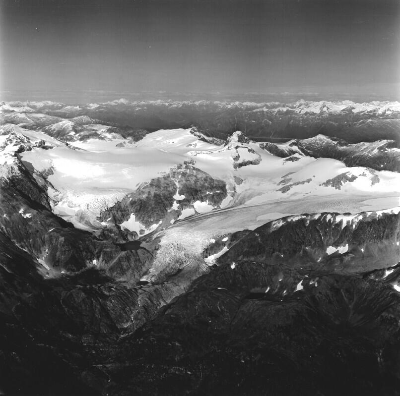
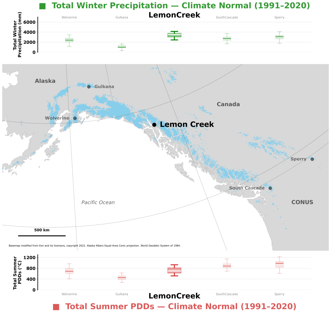
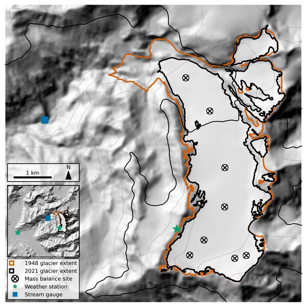
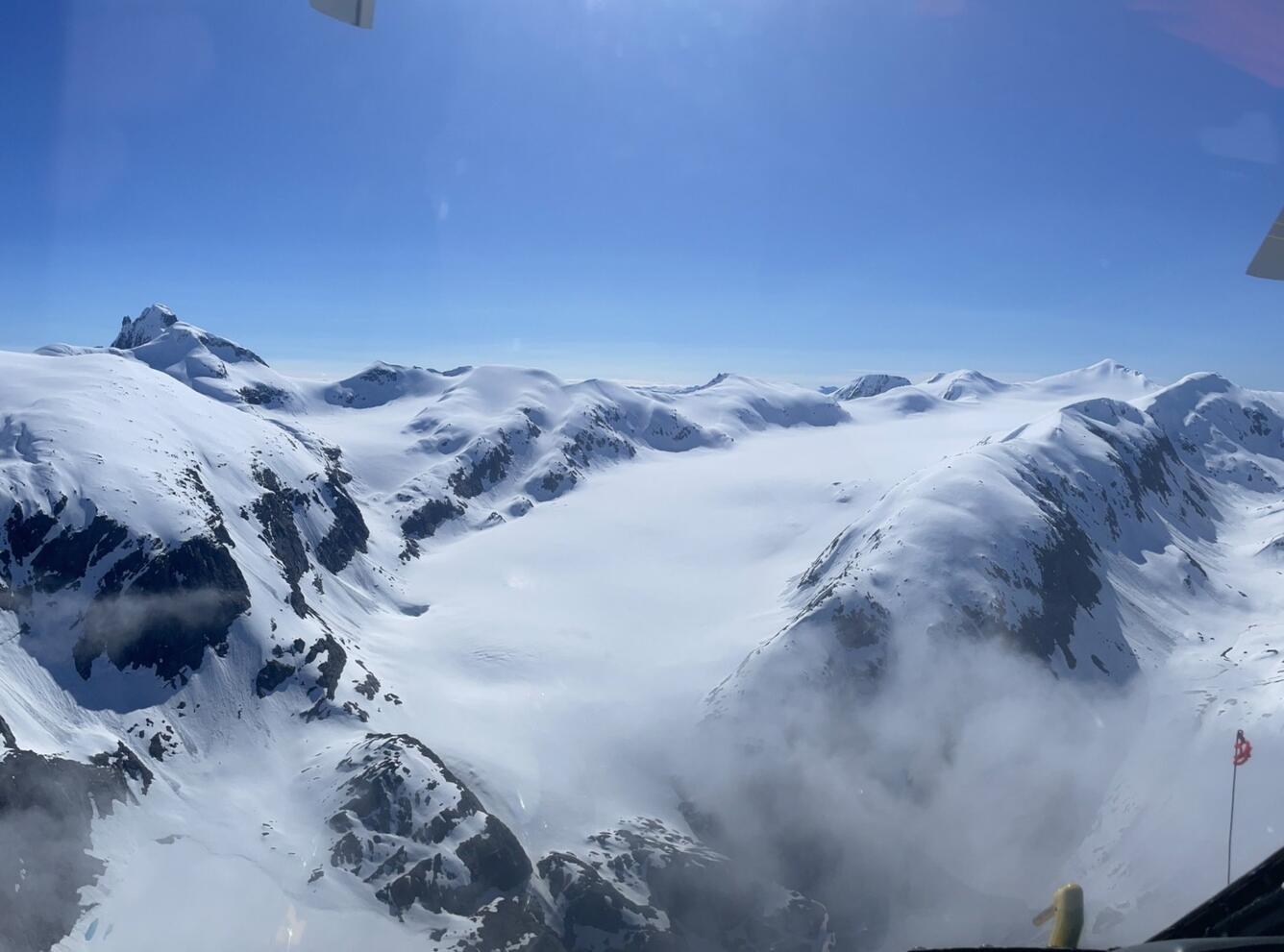
Lemon Creek Glacier is located at the southern tip of the Juneau Icefield in southeast Alaska, USA, approximately 6.5 km northeast of the city of Juneau. Its maritime climate is characterized by high total winter precipitation and moderate summer temperatures (Fig. 1.). The glacier flows northward from its accumulation zone and spans 900 m of elevation, from approximately 600 to 1500 m. Lemon Creek Glacier had an area of 9.7 km2 in 2018, within a 31.9 km2 basin upstream from the USGS stream gauge (O'Neel et al. 2019).
Sources/Usage: Public Domain. View Media Details
Media
Sources/Usage: Public Domain. View Media Details
Media
Sources/Usage: Public Domain. View Media Details
Glacier Mass Balance
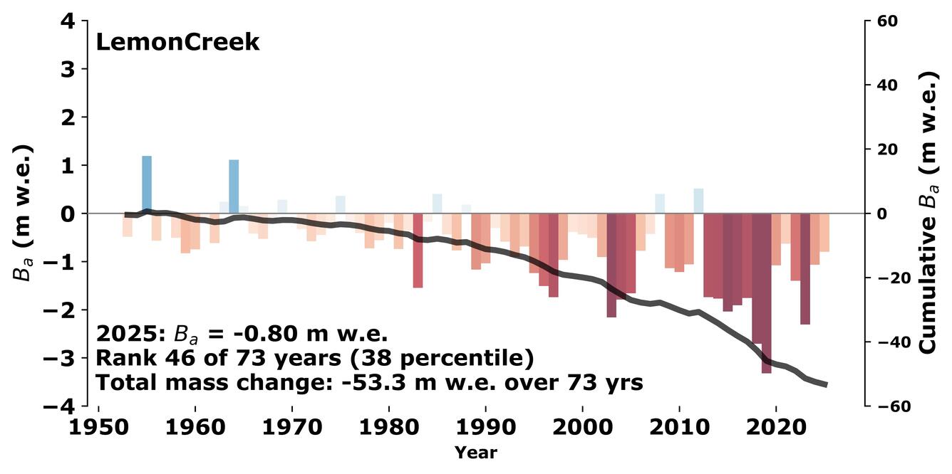
Mass balance measurements began at Lemon Creek Glacier in 1953, under the direction of the Juneau Icefield Research Program (JIRP). Predating the International Geophysical Year (IGY), Lemon Creek Glacier was selected as one of the nine IGY glaciers-- the first efforts towards a distributed glacier-climate monitoring network in North America. Today measurements at Lemon Creek Glacier constitute the second longest continuous mass balance records in North America, providing insight into snow and ice dynamics, hydrology, and the regional impacts of glacier change.
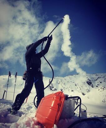
Field visits to measure and maintain stakes at mass balance sites occur each spring at the onset of the melt season, and again in late autumn near its end. Snow pits or cores are collected to measure the density of material gained or lost. By timing visits near the mass balance maxima and minima, measurements closely capture maximum winter accumulation and annual mass balance at each location. In the early 1970s mass balance measurements were largely reduced to annual mid-summer accumulation observations made by JIRP, due to logistical constraints of the program, at four fixed locations in the accumulation zone of Lemon Creek Glacier. The timing and distribution of JIRP mass balance measurements required considerable temporal and spatial extrapolation. Since 2014, additional measurements made by the USGS Benchmark Glacier Project have sought to optimize the timing and distribution of field observations, permitting the incorporation of this mass balance record into the USGS Benchmark Glacier network (O’Neel, and others, 2019) and increase confidence in the long-term record. Since 2016, additional surveying of mass balance stakes have provided both ice velocity and surface elevation change at each site.
Continuing today, field measurements are combined with weather data and imagery analysis to calculate seasonal and annual glacier-wide mass balance. These data are published through an official USGS data release and submitted to the World Glacier Monitoring Service. The most recent mass balance results are available on the USGS Glacier Project executive summary webpage. For more detailed description of methods see: O’Neel et al., 2019 and Florentine et al., 2023.
Media
Sources/Usage: Public Domain. View Media Details
Media
Sources/Usage: Public Domain. View Media Details
Time Series Imagery
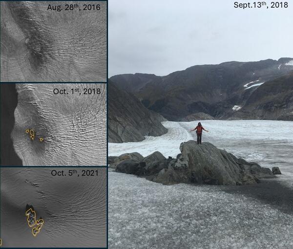
Time series of satellite imagery (left panel of image) illustrates the progressive emergence of a rocky outcrop from the surface of Lemon Creek Glacier between 2016 and 2021. A debris band visible for many years prior to 2016, marks the feature’s position beneath thinning ice. By October 2018 (orange outline), the rock first became exposed, and by 2021 it has expanded substantially. The field photograph (right panel) shows a researcher ground-truthing the feature shortly after emergence.
This transition from debris-covered ice to exposed bedrock reflects sustained surface lowering and highlights evolving surface processes: debris influences albedo and melt rates before exposure, while the emergence of rock creates strong local contrasts in energy balance, affecting melt patterns, ice flow, and crevasse development in the surrounding glacier.
Media
Sources/Usage: Public Domain. View Media Details
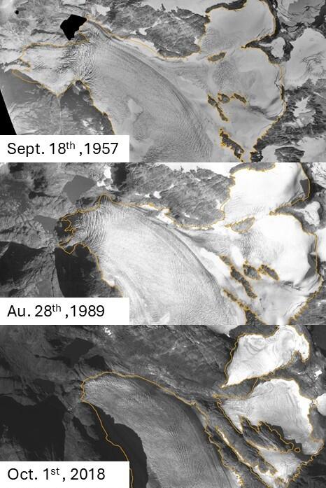
Time series imagery (1957, 1989, 2018) on the left shows the progressive disconnection of tributary branches from Lemon Creek Glacier. In each panel, the glacier extent is outlined in orange. Over time, thinning and retreat isolate formerly connected accumulation areas, reducing ice flux into the main trunk. These disconnections represent important dynamic feedback: as tributaries detach, the delivery of ice from higher-elevation accumulation zones to lower-elevation ablation areas diminishes, contributing to accelerated thinning and mass loss. This pattern is consistent with regional observations from the Juneau Icefield, where glacier fragmentation and reduced ice flux have been linked to increasing rates of mass loss.
Media
Sources/Usage: Public Domain. View Media Details
Meteorologic
Measurements of air temperature data have been collected along the margin of Lemon Creek Glacier during the 1998-2018 period. These data are available through the Alaska Science Center Data Repository for the following parameters:
- Temperature, air (1998 – 2018)
Gaps in data and challenges with instrumentation over the decades have also required the use of meteorological data from the nearby Juneau Airport (ncdc.noaa.gov, Station ID: USW00025309) for mass balance calculations. The airport is located at sea-level, 13 km from the glacier. The data from the Juneau airport were used in the 2019 reanalysis and are available here.
In July 2026, the weather station along the margin of Lemon Creek Glacier was rebuilt. The Lemon Creek weather station (Latitude 58°22'N, Longitude 134°21'W) is located on bedrock along the margin of the glacier’s upper elevations at 1286 m. This elevation is very near that of the glacier's long term average equilibrium line altitude (ELA).
The telemetered subset of current data can be viewed at (USGS Monitoring Location 582202134215701). Current measurements include:
- Passive Air Temperature
- Mechanically Aspirated air Temperature
- Precipitation
- Relative Humidity
- Wind Speed
- Wind gust Speed
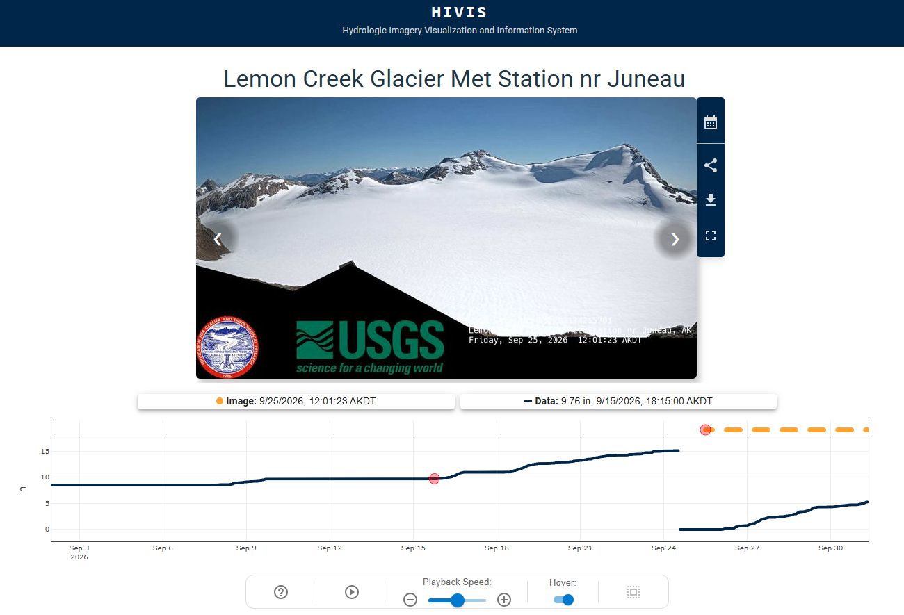
A telemetered camera on USGS HIVIS, added to the weather station in September 2026, will display and archive hourly daylight images. These near-real-time data support glacier research, avalanche forecasting by the Alaska Department of Transportation and Public Facilities (Alaska DOT&PF), aviation, search and rescue, and the outdoor recreation economy of Juneau, Alaska. Provisional data are available through USGS Water Data for the Nation. NOAA partners are working to incorporate the station into daily precipitation estimates. Approved data will be included in the annual Glacier-Adjacent Weather Station data release.
Media
Sources/Usage: Public Domain. View Media Details
Hydrologic
The USGS maintains a gaging station on Lemon Creek downstream of the glacier terminus. Surface water data collection and analysis are conducted by standard techniques developed by the USGS as part of the National Stream gaging Network. Current telemetered data, statistics (annual, daily, monthly means), and archived historical data can be viewed and downloaded at the water data for the nation website: USGS Monitoring Location 15052000. Water data back to 1948 are available.
Location: Latitude: 58°23'30"N, Longitude: 134°25'15 NAD27, City and Borough of Juneau, Alaska, Hydrologic Unit 19010301, within Tongass National Forest. Datum of gage: 203 m above NAVD88.
Drainage Area: 32 km2
Period of Record: August 1951 to current year (discharge data), Field/lab water quality data Oct 1948 to current year, excluding a data gap between 1973-2002.
Media
Sources/Usage: Public Domain. View Media Details
Glaciers and Landscape Change
Mountain glaciers are dynamic reservoirs of frozen water, deeply interconnected with their surrounding ecosystems. Glacier change in North America has major societal impacts, including to water resources, natural hazard risk, tourism disruption, fisheries, and global sea level change. Understanding and quantifying precise connections between changing glaciers, the surrounding landscape and climate...

Gulkana Glacier
Gulkana Glacier is located in the high-latitude continental climate regime of Alaska’s Delta Mountains. Glacier observations began at this site in 1966 and continue through present as the northern most USGS Benchmark Glacier.
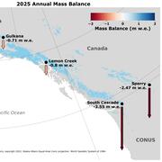
2025 USGS Benchmark Glaciers Executive Summary
2025 Data Now Available: Explore how the USGS Benchmark Glaciers have changed in 2025

Mass Balance Methods: Measuring Glacier Change
Nearly all of Earth's alpine glaciers are losing mass, with consequences for freshwater resources, landscape stability, regional ecosystems, and global sea level. Rates of glacier mass loss in Western North America and Alaska are among the highest on Earth (The GlaMBIE Team, 2025).

Additional Research Glaciers
The USGS Glacier Project has conducted research beyond the Benchmark Glaciers, both past and present. This work has focused on infrastructure hazards, rapid glacier change, landscape destabilization, and glacier dynamics and processes not captured by the Benchmark Glacier network. These glaciers include Black Rapids, Kahiltna, Kennicott, Columbia, Hubbard, and Taku.

Wolverine Glacier
Wolverine Glacier is located in the high-latitude maritime climate regime of Alaska’s Kenai Mountains. Glacier observations began at this site in 1966.
South Cascade Glacier
South Cascade Glacier is located in the midlatitude maritime climate of the North Cascade Mountains of Washington State. Glacier observations began at this site in 1958.

Sperry Glacier
Sperry Glacier is located along the Continental Divide within Glacier National Park, Montana. It represents the midlatitude continental or transitional climate. Glacier observations began at this site in 2005.

Lemon Creek Glacier
Researchers walk amid the glacial ice and crevasses left bare by summer melt on Lemon Creek Glacier, AK.

Lemon Creek Glacier
Two USGS scientists walk across the surface of Lemon Creek Glacier near the end of the melt season surrounded by green hills and barren rock.
Two USGS scientists walk across the surface of Lemon Creek Glacier near the end of the melt season surrounded by green hills and barren rock.

Lemon Creek Glacier
Lemon Creek Glacier is located at the southernmost tip of the Juneau Icefield in Southeast Alaska, USA, approximately 6.5 km northeast of the city of Juneau.
Lemon Creek Glacier is located at the southernmost tip of the Juneau Icefield in Southeast Alaska, USA, approximately 6.5 km northeast of the city of Juneau.

Lemon Creek Glacier in the spring
Lemon Creek Glacier is located in the high-latitude maritime region of Alaska, at the southernmost tip of the Juneau Icefield. Glacier observations began at this site in 1953.
Lemon Creek Glacier is located in the high-latitude maritime region of Alaska, at the southernmost tip of the Juneau Icefield. Glacier observations began at this site in 1953.
Lemon Creek Glacier is located in southeast Alaska, at the southernmost tip of the Juneau Icefield. Glacier observations began at this site in 1953 and continue through present, serving as a central site between glaciers in the contiguous USA and those in mainland Alaska.
Return to Glaciers and Landscape Change
Lemon Creek Glacier is located at the southern tip of the Juneau Icefield in southeast Alaska, USA, approximately 6.5 km northeast of the city of Juneau. Its maritime climate is characterized by high total winter precipitation and moderate summer temperatures (Fig. 1.). The glacier flows northward from its accumulation zone and spans 900 m of elevation, from approximately 600 to 1500 m. Lemon Creek Glacier had an area of 9.7 km2 in 2018, within a 31.9 km2 basin upstream from the USGS stream gauge (O'Neel et al. 2019).
Sources/Usage: Public Domain. View Media Details
Media
Sources/Usage: Public Domain. View Media Details
Media
Sources/Usage: Public Domain. View Media Details
Glacier Mass Balance
Mass balance measurements began at Lemon Creek Glacier in 1953, under the direction of the Juneau Icefield Research Program (JIRP). Predating the International Geophysical Year (IGY), Lemon Creek Glacier was selected as one of the nine IGY glaciers-- the first efforts towards a distributed glacier-climate monitoring network in North America. Today measurements at Lemon Creek Glacier constitute the second longest continuous mass balance records in North America, providing insight into snow and ice dynamics, hydrology, and the regional impacts of glacier change.
Field visits to measure and maintain stakes at mass balance sites occur each spring at the onset of the melt season, and again in late autumn near its end. Snow pits or cores are collected to measure the density of material gained or lost. By timing visits near the mass balance maxima and minima, measurements closely capture maximum winter accumulation and annual mass balance at each location. In the early 1970s mass balance measurements were largely reduced to annual mid-summer accumulation observations made by JIRP, due to logistical constraints of the program, at four fixed locations in the accumulation zone of Lemon Creek Glacier. The timing and distribution of JIRP mass balance measurements required considerable temporal and spatial extrapolation. Since 2014, additional measurements made by the USGS Benchmark Glacier Project have sought to optimize the timing and distribution of field observations, permitting the incorporation of this mass balance record into the USGS Benchmark Glacier network (O’Neel, and others, 2019) and increase confidence in the long-term record. Since 2016, additional surveying of mass balance stakes have provided both ice velocity and surface elevation change at each site.
Continuing today, field measurements are combined with weather data and imagery analysis to calculate seasonal and annual glacier-wide mass balance. These data are published through an official USGS data release and submitted to the World Glacier Monitoring Service. The most recent mass balance results are available on the USGS Glacier Project executive summary webpage. For more detailed description of methods see: O’Neel et al., 2019 and Florentine et al., 2023.
Media
Sources/Usage: Public Domain. View Media Details
Media
Sources/Usage: Public Domain. View Media Details
Time Series Imagery
Time series of satellite imagery (left panel of image) illustrates the progressive emergence of a rocky outcrop from the surface of Lemon Creek Glacier between 2016 and 2021. A debris band visible for many years prior to 2016, marks the feature’s position beneath thinning ice. By October 2018 (orange outline), the rock first became exposed, and by 2021 it has expanded substantially. The field photograph (right panel) shows a researcher ground-truthing the feature shortly after emergence.
This transition from debris-covered ice to exposed bedrock reflects sustained surface lowering and highlights evolving surface processes: debris influences albedo and melt rates before exposure, while the emergence of rock creates strong local contrasts in energy balance, affecting melt patterns, ice flow, and crevasse development in the surrounding glacier.
Media
Sources/Usage: Public Domain. View Media Details
Time series imagery (1957, 1989, 2018) on the left shows the progressive disconnection of tributary branches from Lemon Creek Glacier. In each panel, the glacier extent is outlined in orange. Over time, thinning and retreat isolate formerly connected accumulation areas, reducing ice flux into the main trunk. These disconnections represent important dynamic feedback: as tributaries detach, the delivery of ice from higher-elevation accumulation zones to lower-elevation ablation areas diminishes, contributing to accelerated thinning and mass loss. This pattern is consistent with regional observations from the Juneau Icefield, where glacier fragmentation and reduced ice flux have been linked to increasing rates of mass loss.
Media
Sources/Usage: Public Domain. View Media Details
Meteorologic
Measurements of air temperature data have been collected along the margin of Lemon Creek Glacier during the 1998-2018 period. These data are available through the Alaska Science Center Data Repository for the following parameters:
- Temperature, air (1998 – 2018)
Gaps in data and challenges with instrumentation over the decades have also required the use of meteorological data from the nearby Juneau Airport (ncdc.noaa.gov, Station ID: USW00025309) for mass balance calculations. The airport is located at sea-level, 13 km from the glacier. The data from the Juneau airport were used in the 2019 reanalysis and are available here.
In July 2026, the weather station along the margin of Lemon Creek Glacier was rebuilt. The Lemon Creek weather station (Latitude 58°22'N, Longitude 134°21'W) is located on bedrock along the margin of the glacier’s upper elevations at 1286 m. This elevation is very near that of the glacier's long term average equilibrium line altitude (ELA).
The telemetered subset of current data can be viewed at (USGS Monitoring Location 582202134215701). Current measurements include:
- Passive Air Temperature
- Mechanically Aspirated air Temperature
- Precipitation
- Relative Humidity
- Wind Speed
- Wind gust Speed
A telemetered camera on USGS HIVIS, added to the weather station in September 2026, will display and archive hourly daylight images. These near-real-time data support glacier research, avalanche forecasting by the Alaska Department of Transportation and Public Facilities (Alaska DOT&PF), aviation, search and rescue, and the outdoor recreation economy of Juneau, Alaska. Provisional data are available through USGS Water Data for the Nation. NOAA partners are working to incorporate the station into daily precipitation estimates. Approved data will be included in the annual Glacier-Adjacent Weather Station data release.
Media
Sources/Usage: Public Domain. View Media Details
Hydrologic
The USGS maintains a gaging station on Lemon Creek downstream of the glacier terminus. Surface water data collection and analysis are conducted by standard techniques developed by the USGS as part of the National Stream gaging Network. Current telemetered data, statistics (annual, daily, monthly means), and archived historical data can be viewed and downloaded at the water data for the nation website: USGS Monitoring Location 15052000. Water data back to 1948 are available.
Location: Latitude: 58°23'30"N, Longitude: 134°25'15 NAD27, City and Borough of Juneau, Alaska, Hydrologic Unit 19010301, within Tongass National Forest. Datum of gage: 203 m above NAVD88.
Drainage Area: 32 km2
Period of Record: August 1951 to current year (discharge data), Field/lab water quality data Oct 1948 to current year, excluding a data gap between 1973-2002.
Media
Sources/Usage: Public Domain. View Media Details
Glaciers and Landscape Change
Mountain glaciers are dynamic reservoirs of frozen water, deeply interconnected with their surrounding ecosystems. Glacier change in North America has major societal impacts, including to water resources, natural hazard risk, tourism disruption, fisheries, and global sea level change. Understanding and quantifying precise connections between changing glaciers, the surrounding landscape and climate...
Gulkana Glacier
Gulkana Glacier is located in the high-latitude continental climate regime of Alaska’s Delta Mountains. Glacier observations began at this site in 1966 and continue through present as the northern most USGS Benchmark Glacier.
2025 USGS Benchmark Glaciers Executive Summary
2025 Data Now Available: Explore how the USGS Benchmark Glaciers have changed in 2025
Mass Balance Methods: Measuring Glacier Change
Nearly all of Earth's alpine glaciers are losing mass, with consequences for freshwater resources, landscape stability, regional ecosystems, and global sea level. Rates of glacier mass loss in Western North America and Alaska are among the highest on Earth (The GlaMBIE Team, 2025).
Additional Research Glaciers
The USGS Glacier Project has conducted research beyond the Benchmark Glaciers, both past and present. This work has focused on infrastructure hazards, rapid glacier change, landscape destabilization, and glacier dynamics and processes not captured by the Benchmark Glacier network. These glaciers include Black Rapids, Kahiltna, Kennicott, Columbia, Hubbard, and Taku.
Wolverine Glacier
Wolverine Glacier is located in the high-latitude maritime climate regime of Alaska’s Kenai Mountains. Glacier observations began at this site in 1966.
South Cascade Glacier
South Cascade Glacier is located in the midlatitude maritime climate of the North Cascade Mountains of Washington State. Glacier observations began at this site in 1958.
Sperry Glacier
Sperry Glacier is located along the Continental Divide within Glacier National Park, Montana. It represents the midlatitude continental or transitional climate. Glacier observations began at this site in 2005.
Lemon Creek Glacier
Researchers walk amid the glacial ice and crevasses left bare by summer melt on Lemon Creek Glacier, AK.
Researchers walk amid the glacial ice and crevasses left bare by summer melt on Lemon Creek Glacier, AK.
Lemon Creek Glacier
Two USGS scientists walk across the surface of Lemon Creek Glacier near the end of the melt season surrounded by green hills and barren rock.
Two USGS scientists walk across the surface of Lemon Creek Glacier near the end of the melt season surrounded by green hills and barren rock.
Lemon Creek Glacier
Lemon Creek Glacier is located at the southernmost tip of the Juneau Icefield in Southeast Alaska, USA, approximately 6.5 km northeast of the city of Juneau.
Lemon Creek Glacier is located at the southernmost tip of the Juneau Icefield in Southeast Alaska, USA, approximately 6.5 km northeast of the city of Juneau.
Lemon Creek Glacier in the spring
Lemon Creek Glacier is located in the high-latitude maritime region of Alaska, at the southernmost tip of the Juneau Icefield. Glacier observations began at this site in 1953.
Lemon Creek Glacier is located in the high-latitude maritime region of Alaska, at the southernmost tip of the Juneau Icefield. Glacier observations began at this site in 1953.