
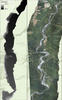
Middle Elwha River digital elevation model and orthophotomosaic

Detailed Description
Digital elevation model (left) and orthomosaic (right) of the middle Elwha River
Sources/Usage
Public Domain.
USGS Data Release
Ritchie, A.C., Curran, C.A., Magirl, C.S., Bountry, J.A., Hilldale, R.C., Randle, T.J., and Duda, J.J., 2018, Data in support of 5-year sediment budget and morphodynamic analysis of Elwha River following dam removals: U.S. Geological Survey data release, https://doi.org/10.5066/F7PG1QWC.