
Mokelumne River Bathymetry
By Pacific Coastal and Marine Science Center
July 2018 (approx.)

Detailed Description
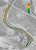
A winding strip of rainbow colors shows the bathymetry (depth) of the bed of the Mokelumne River just above its confluence with the San Joaquin in the Sacramento-San Joaquin River Delta east of San Francisco Bay. USGS scientists mapped the channel as part of a project to assess the impact of invasive aquatic vegetation on sediment movement in the Delta. Orange colors are shallowest areas; blue colors are deepest. Note sand waves (rippled texture) produced by strong currents in the deep stretch left of center. Aerial photo, USGS National Map.
Sources/Usage
Public Domain.