
National Land Cover Database

Detailed Description
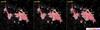
The suite of GIS mapping products from the USGS National Land Cover Database includes a layer that defines the intensity of impervious surfaces across the U.S. This data factors into runoff modeling, urban heat, and much more. NLCD 2019 includes impervious surface layers for eight separate calendar years, allowing users to compare changes to urban areas. This image compares the impervious surfaces of Boise, ID from 2001, 2008, and 2019.
Sources/Usage
Public Domain.
Related

LCMAP and NLCD: Complementary Data for Understanding the Geography of the United States
Land Change Monitoring, Assessment, and Projection (LCMAP) Collection 1 science products provide unprecedented monitoring of past changes occurring in land cover and condition across the conterminous U.S. over more than 30 years at an annual timestep.
Related
LCMAP and NLCD: Complementary Data for Understanding the Geography of the United States
Land Change Monitoring, Assessment, and Projection (LCMAP) Collection 1 science products provide unprecedented monitoring of past changes occurring in land cover and condition across the conterminous U.S. over more than 30 years at an annual timestep.