
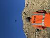
USGS remote pilot flies a UAS at the Cimarron Canyon in New Mexico

Detailed Description
USGS remote pilot Mark Bauer flies a UAS with a stabilized gimbal with vibration dampening mounted with a Sony A7r camera with a locked focus using a 14mm wide angle lens at the Cimarron Canyon in New Mexico. This unique mapping payload allowed the team to collect a complex series of images (with ideal geometry) from various angles around the outcrops achieving a sharply focused set of overlapping images covering a considerable depth-of-field.
NUSO researchers worked with USGS geologists in September 2021 to establish and test unique photogrammetric data collection techniques utilizing UAS along the Paleocene Poison Canyon Formation in the Cimarron Canyon.
Sources/Usage
Public Domain.