
Offshore central California bathymetry

Detailed Description
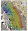
Colored, shaded-relief bathymetry offshore central California. Data supported management of National Marine Sanctuaries and prospective renewable energy decisions. Black ovals are locations of AUV-based multibeam surveys. Close-up views of two AUV surveys are shown in Figures 4 and 5.
Figure 1: EXPRESS surveys, dives, and sampling locations
Figure 2: Trinidad Submarine Canyon bathymetry
Figure 3: Offshore central California bathymetry (this map)
Figure 4: Morro Bay bathymetry
Figure 5: Morro Bay bathymetry
Sources/Usage
Public Domain.