
Oso landslide, 3DEP
By Communications and Publishing
2014 (approx.)

Detailed Description
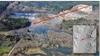
Aerial photo of the Oso, Washington landslide in 2014. The red arrows show the direction of material flow. The inset lidar image was derived from 3DEP data collected by the Washington Department of Transportation.
Sources/Usage
Public Domain.